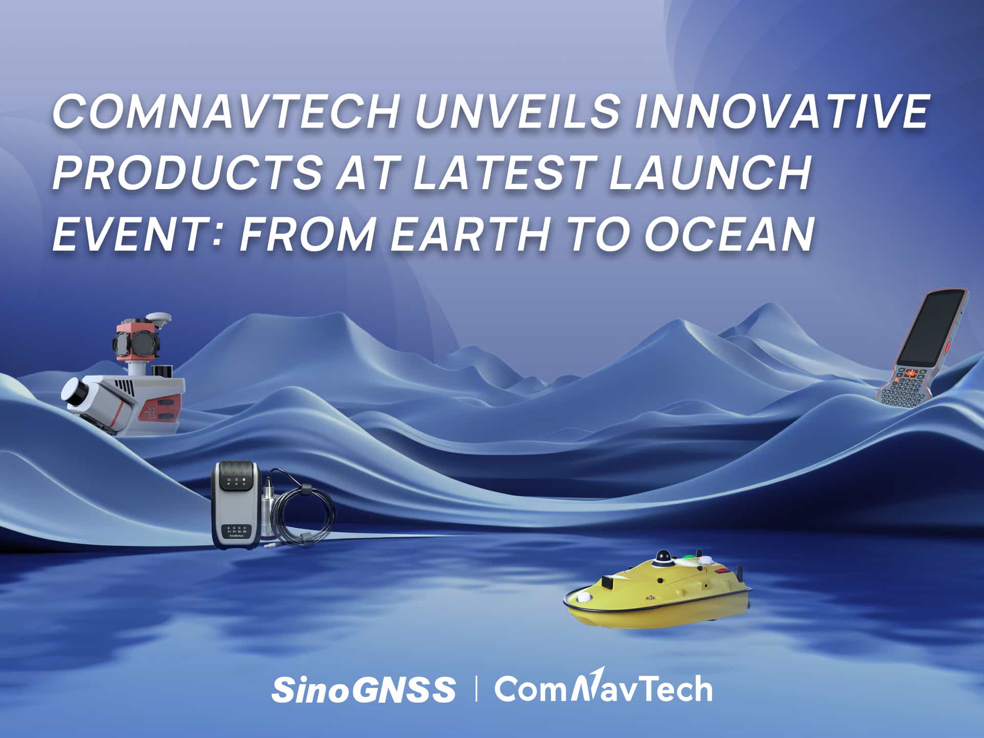

ComNavTech Unveils Innovative Products at Latest Launch Event: From Earth to Ocean
Shanghai, China, November 20, 2025 — At our recent product launch event, ComNav Technology unveiled its new technological ecosystem to the industry. Under the theme “From Earth to Ocean,” we presented a suite of next-generation innovations engineered to advance the frontiers of geospatial and hydrographic intelligence.
Among the key highlights were four newly released products — the ML300 Mobile Laser Scanning System, R80 GNSS Data Collector, SV300 Unmanned Surface Vessel, and HYD10 Portable Echo Sounder. Each delivers significant technological advancements and unique capabilities, further underscoring ComNav Technology’s innovation strength across the industry.
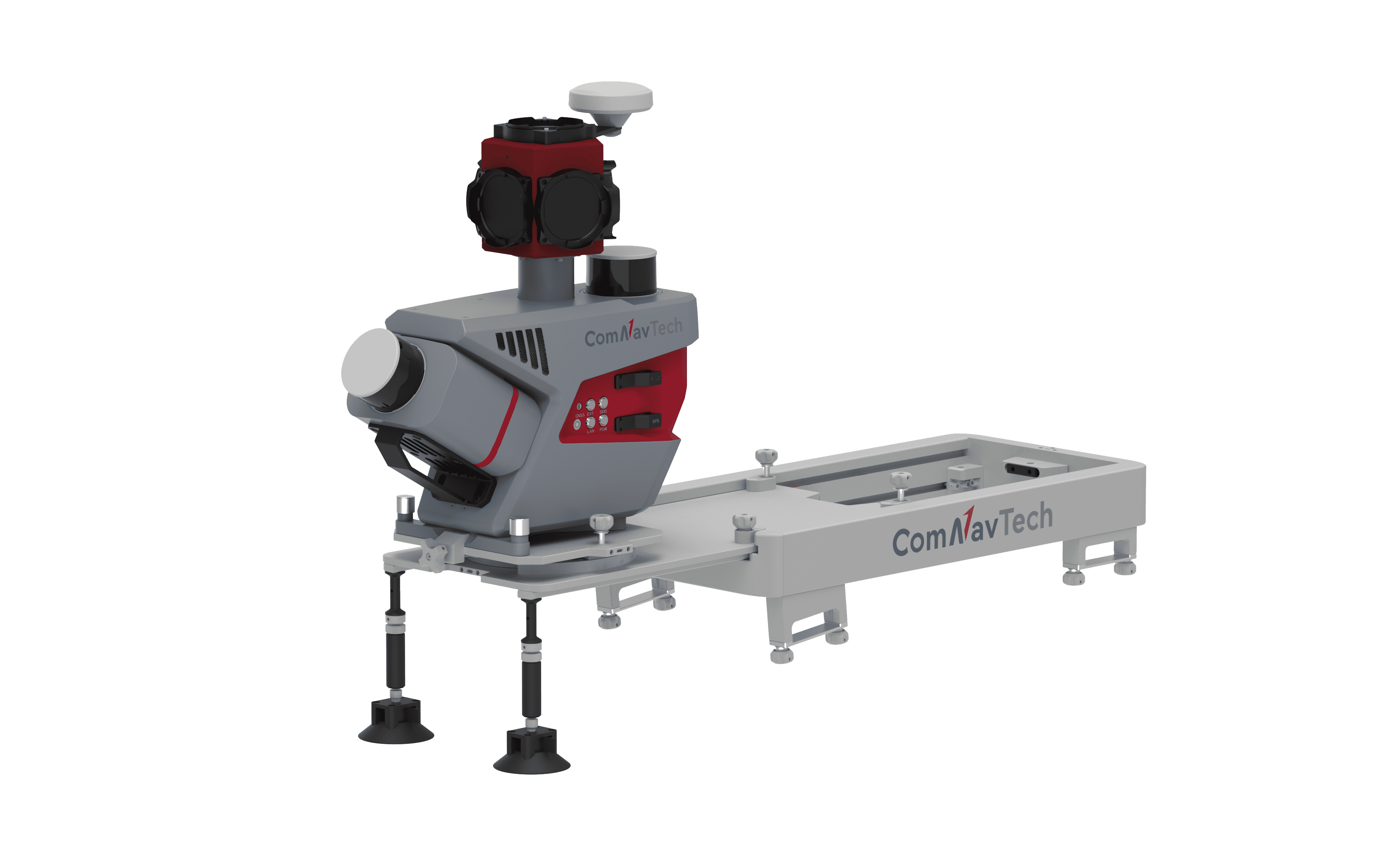
➤ ML300 Mobile Laser Scanning System: Precision in Complex Environments, Redefining Surveying
The ML300 Mobile Laser Scanning System is a cutting-edge solution designed for large-scale surveying projects and complex environments. It incorporates multi-mode fusion positioning technology, integrating GNSS, IMU, DMI, and Laser SLAM, providing a new approach to 3D scene reconstruction.
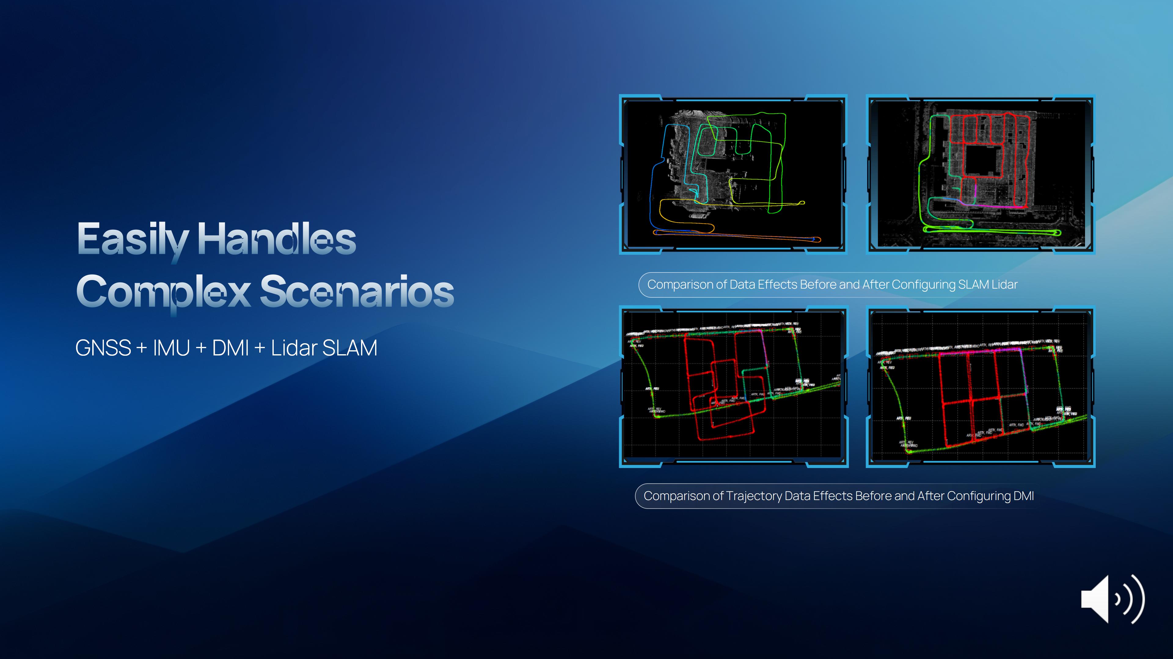
This system is ideal for environments where GNSS signals are limited or entirely lost, such as tunnels, urban canyons, and densely built-up areas. In these challenging environments, traditional surveying methods often fail to deliver the required precision, but with ML300's intelligent multi-mode positioning, we ensure accurate 3D scene reconstruction regardless of the conditions.
The core advantages of the ML300 lie in its high precision and flexibility. By combining Laser SLAM and DMI technologies, it can operate effectively without GNSS signals, eliminating errors and improving modeling accuracy. This breakthrough offers new solutions for large-scale land surveys, urban infrastructure monitoring, and smart city planning, among others.
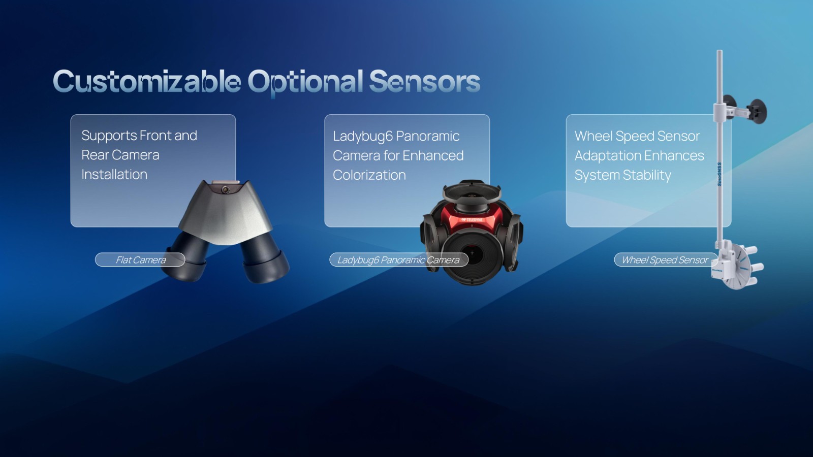
Designed for operational efficiency, the ML300 boasts a modular and highly flexible design. It can be customized with various sensors, including road cameras, Ladybug 6 panoramic cameras, and wheel encoders, making it adaptable to a wide range of project needs. Additionally, with up to 6 hours of battery life and external power source support, the ML300 ensures stable performance during long working hours.
Whether for highway surveys, urban power line inspections, dynamic forestry management, or smart transportation system development, the ML300 provides precise and efficient data support, facilitating digital transformation across various industries.
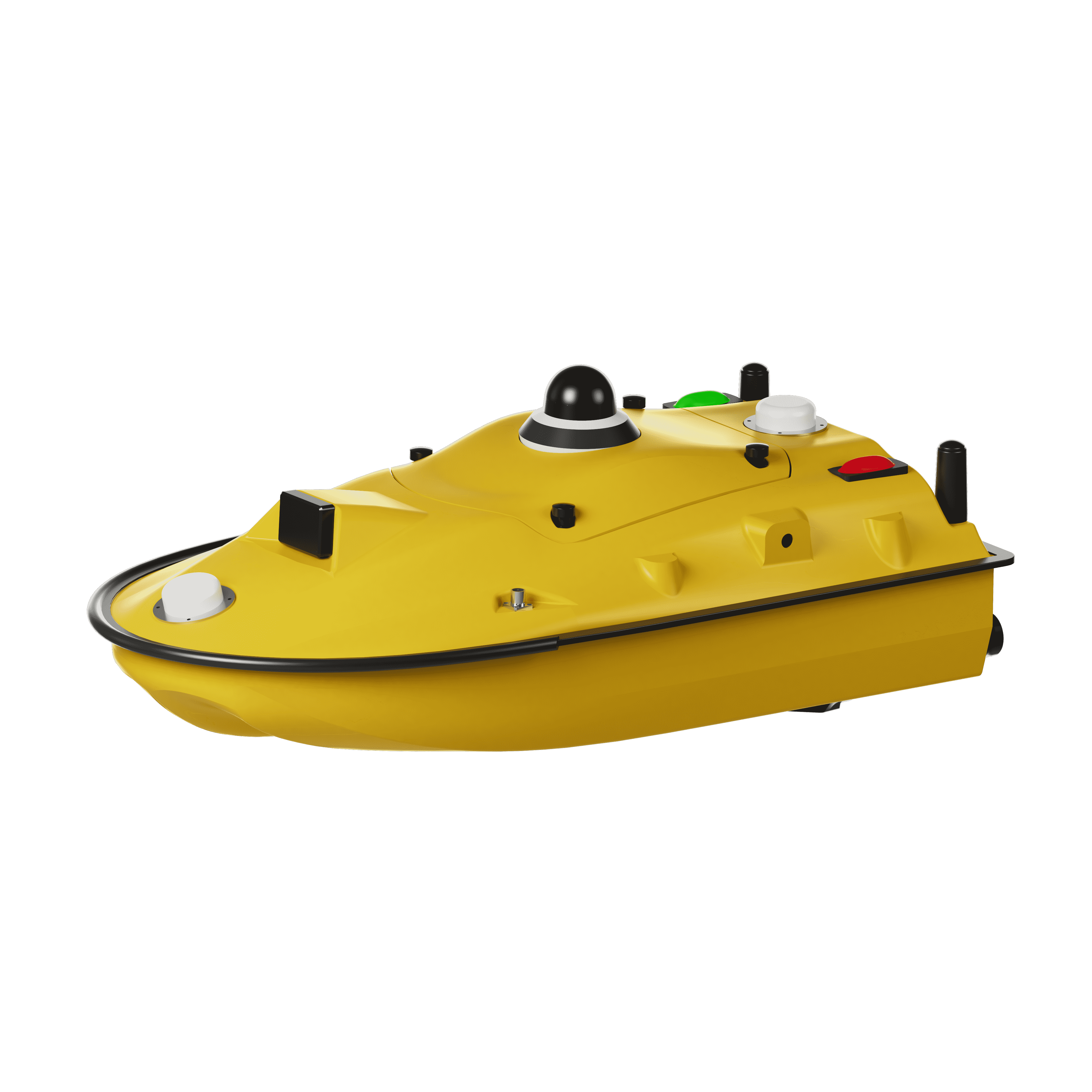
➤ SV300 Unmanned Surface Vessel : Intelligent Underwater Surveying, Disrupting Traditional Hydrographic Exploration
The SV300 Unmanned Surface Vessel was designed specifically for intelligent underwater surveying. This autonomous vessel is optimized for operation in complex aquatic environments, integrating high-precision GNSS positioning, AI technologies, and autonomous navigation capabilities, enhancing both the efficiency and accuracy of hydrographic surveys.
The design of the SV300 focuses on making underwater exploration smarter, safer, and more efficient. Its ultra-light design (weighing only 28 kg) and compact hull (less than 1 meter in length) enable single-person operation, eliminating the high labor intensity traditionally associated with underwater exploration. For operations requiring high mobility and compact transportation, the SV300 is ideally suited, easily stored in the trunk of a small vehicle.
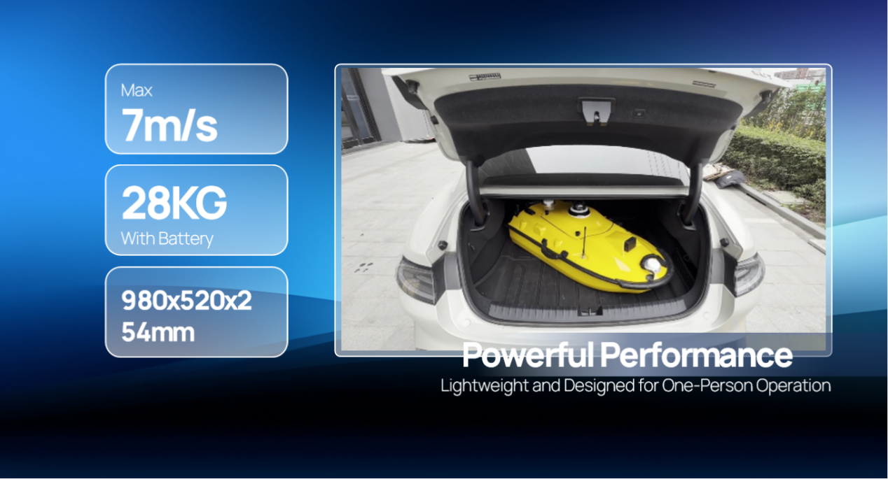
Equipped with a high-performance single-beam bathymetric measurement system, the SV300 can measure depths up to 200 meters, ensuring reliable data even in challenging aquatic environments. Its streamlined hull and powerful motor enable a top speed of 7 meters per second, accelerating survey speeds without compromising accuracy, significantly enhancing operational efficiency.
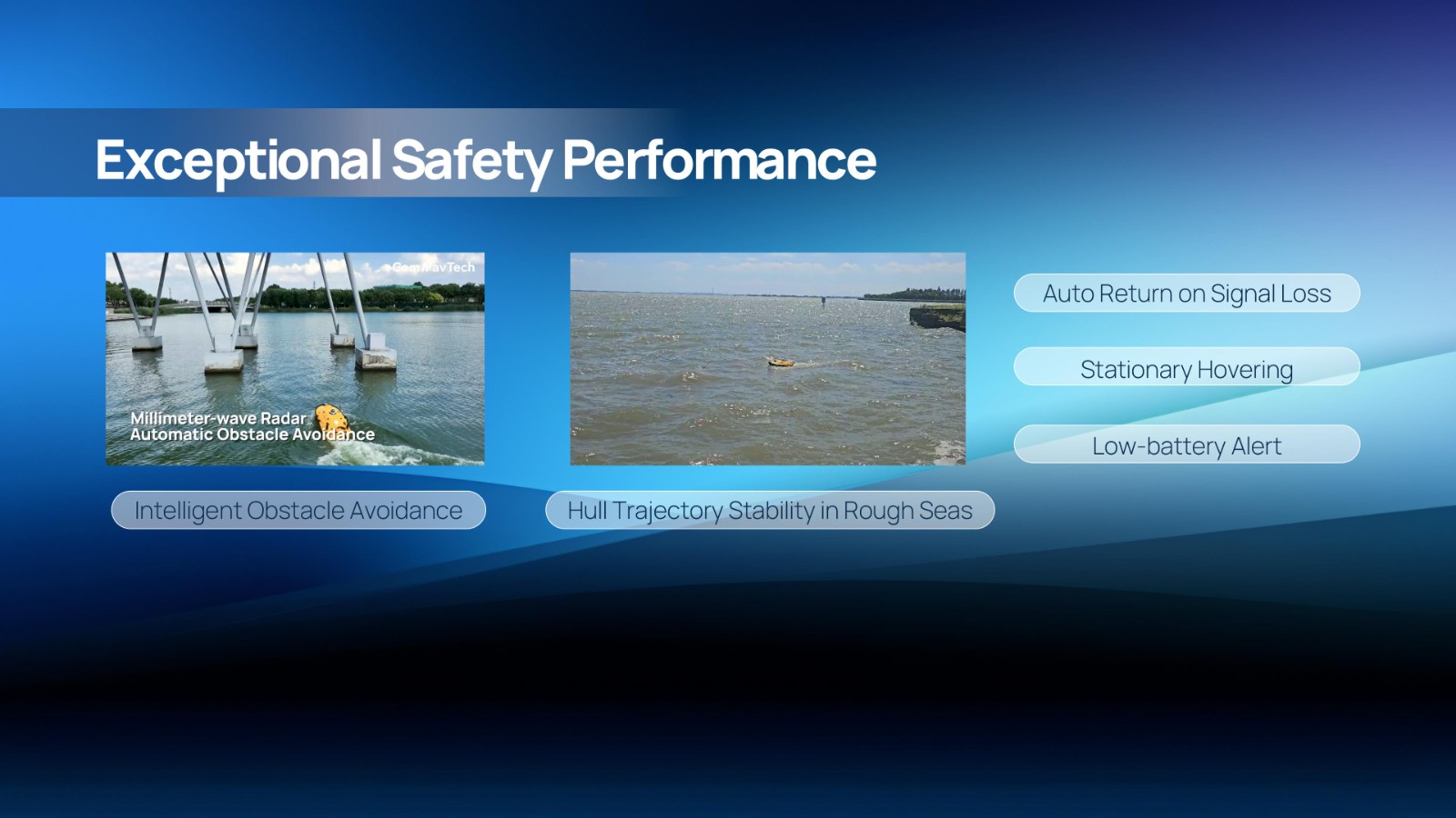
Safety is paramount in the design of the SV300. It includes an intelligent obstacle avoidance system that detects and avoids obstacles in real time, preventing collisions while operating in water. In harsh marine conditions, the SV300 maintains stable hull trajectory, mitigating positional drift caused by wave fluctuations. Additionally, it features intelligent safety functions, such as low battery alerts, stationary hovering, and automatic return in case of signal loss, ensuring stable operation under complex conditions.
The SV300 also includes an intelligent remote controller that integrates control, measurement, and post-processing functions, streamlining the operation process and improving data collection and analysis. With cloud platform integration, the SV300 can upload real-time data and precisely mark target objects, providing end-to-end support for underwater surveying tasks.
The intelligent features of the SV300 not only enhance measurement efficiency but also ensure the safety of personnel. Whether used for river, lake, or ocean surveys, or in emergency response and pipeline inspections, the SV300 adapts effortlessly to complex environments, becoming a reliable partner for underwater exploration.
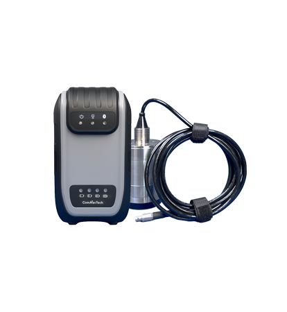
➤ HYD10 Portable Echo Sounder: Compact and Precise
The HYD10 is a lightweight, high-precision echo sounder designed for modern surveying tasks. Weighing just 0.3 kg for the main unit and 1.5 kg for the transducer, it’s incredibly portable, making it easy for a single operator to carry and operate. Its compact design and Bluetooth capability allow it to function seamlessly in tight spaces and complex environments, removing the need for cumbersome cables.
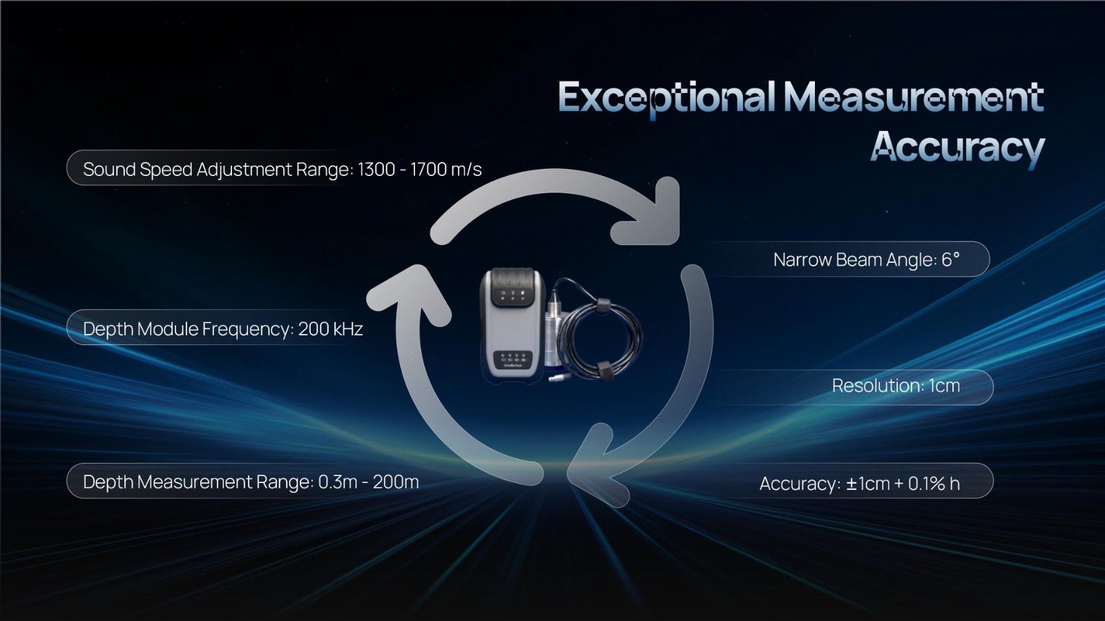
With a measurement depth range of 0.3m to 200m, the HYD10 provides high-precision readings, boasting an accuracy of ±1 cm + 0.1% of water depth and a 1 cm resolution. The 200 kHz depth module and narrow 6° beam angle ensure precise, clear data, while an adjustable sound speed range (1300-1700 m/s) adapts to different water conditions.
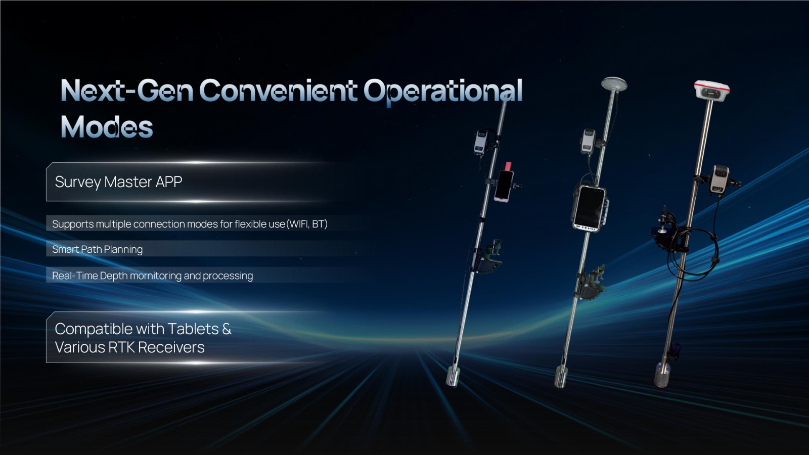
For greater operational flexibility, the HYD10 integrates with Survey Master software, supporting real-time monitoring, data processing, and wireless connections through Wi-Fi and Bluetooth. It is compatible with a variety of positioning devices, including the P6H and P8H tablets, as well as a wide range of RTK receivers. The P6H provides centimeter-level positioning accuracy, while the P8H offers flexible antenna adjustments for various field conditions.
With an 8-hour battery life, a rugged design built to withstand harsh environments, and user-friendly software, the HYD10 simplifies depth measurement, offering an efficient, accurate, and portable solution.
➤ R80 GNSS Data Collector: Precision in Your Hands
The R80 GNSS Data Collector is a groundbreaking tool designed to revolutionize field technology. Engineered for the most demanding tasks in construction, mining, surveying, and GIS, the R80 is your most reliable and powerful partner in the field.
At the heart of the R80 is its octa-core processor, delivering rapid CAD and map loading, ensuring smooth operation and a significant boost in productivity. The ergonomic design with an 18-degree golden grip angle maximizes one-hand comfort, reducing fatigue during long hours of operation.
The R80 features Ultra-Wide Mechanical Keys with tactile feedback, offering precise control with a 0.8mm travel and pressure sensing. It also includes Custom Quick-Measure Keys for easy access to measurement functions, allowing for instant use no matter how you hold the device.
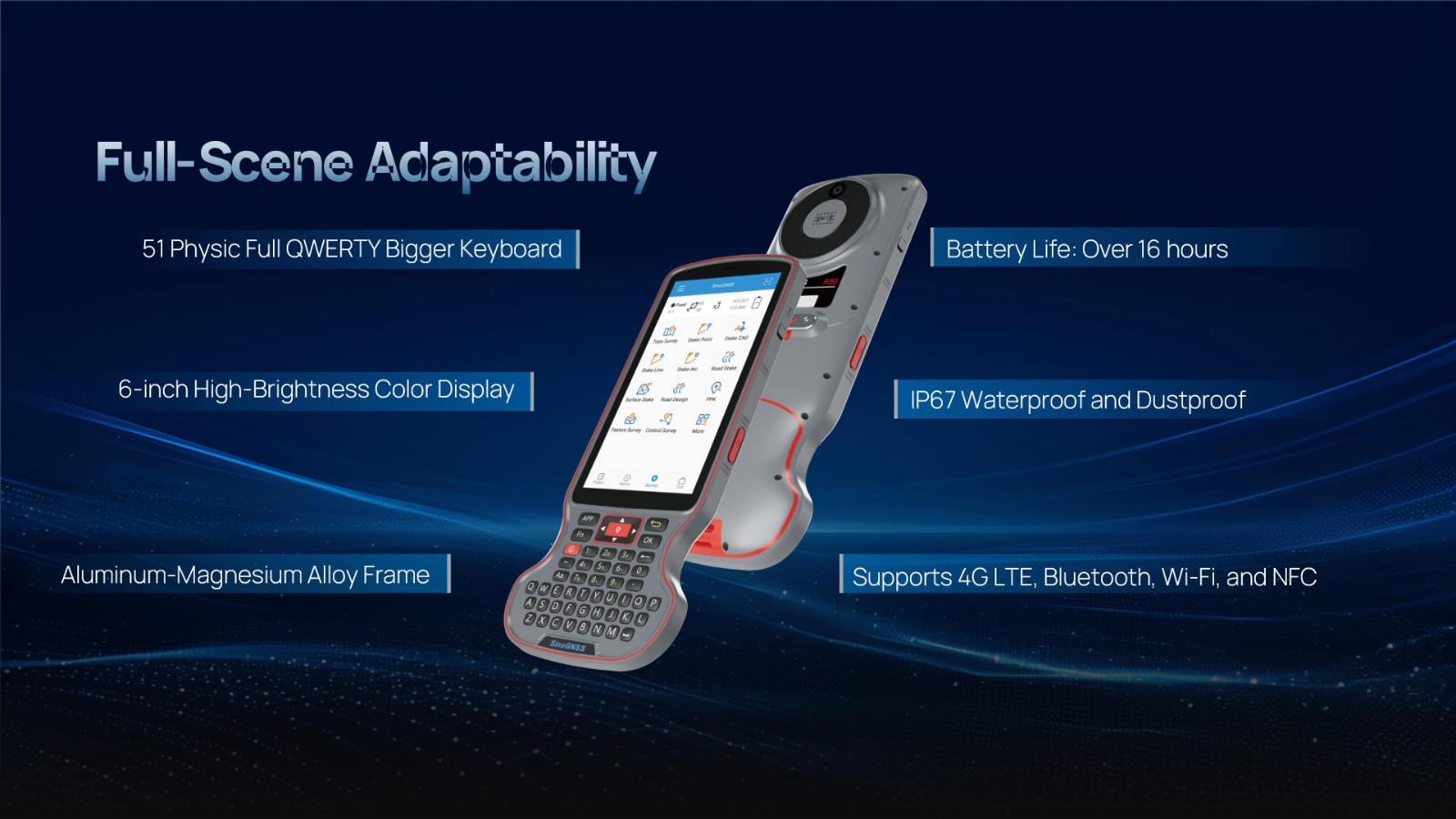
Adaptable to any environment, the R80 boasts a large 51-key backlit keyboard and a stunning 6-inch 1080P display, ensuring clear visibility even in direct sunlight. With a 9000mAh battery, it supports over 16 hours of continuous operation. Built to withstand tough conditions, it holds an IP67 rating for water and dust resistance and has passed a 1.5-meter drop test.
Connectivity is seamless with support for 4G LTE, Bluetooth, Wi-Fi, and NFC, along with a 13MP autofocus camera for high-definition imagery. The Survey Master software, integrated with a self-developed CADX engine, enhances performance by enabling the instant opening of large drawings and ensuring smooth field operations.
The R80 is truly the next-generation GNSS data collector, offering unmatched durability, intuitive control, and efficient data collection in the most demanding environments.
➤ Looking Ahead: Technology Driving the Future of Surveying
With these groundbreaking products, ComNav Technology continues to lead the surveying industry, pushing the boundaries of what is possible. Whether for land-based surveys, intelligent underwater exploration, or portable depth measurement, our products are shaping a smarter, more efficient future for the industry.
As these technologies continue to evolve, we believe the surveying industry will experience further breakthroughs, enabling customers around the world to perform measurements more accurately and efficiently. ComNav Technology will continue to drive innovation, leading the industry toward greater automation and intelligence in the years to come.
About ComNav Technology
ComNav Technology develops and manufactures GNSS OEM boards and receivers for high precision positioning demanded applications. Its technology already been used in a wide range of applications such as surveying, construction, machine control, agriculture, intelligent transportation, precise timing, deformation monitoring, unmanned system. With a team dedicated for the GNSS technology, ComNav Technology is trying its best to supply reliable and competitive products to worldwide customers. ComNav Technology has been listed on the Shanghai Stock Exchange (Science and Technology Board), securities :ComNav Technology (Compass Navigation), Stock code: 688592.
About SinoGNSS®
SinoGNSS® is the official trademark of ComNav Technology Ltd., registered in People's Republic of China, EU, USA and Canada. All other trademarks are the property of their respective owners.
About ComNavTech®
ComNavTech® is the official trademark of ComNav Technology Ltd., registered in People's Republic of China, EU, USA and Canada. All other trademarks are the property of their respective owners.