ML300 Mobile Laser Scanning System
Introduction
Product Parameter
Download
Get Information
Introduction
The ML300 affordable mobile laser scanning (MLS) system is equipped with two LiDAR sensors (one tilted at a 30-degree angle and one positioned horizontally) and a Ladybug5+ panoramic camera, enabling efficient 3D mapping of roads and surrounding environments. Paired with LiDAR360MLS software, it enables a one-stop data processing for applications such as road asset extraction, urban power distribution line analysis, urban forestry management, smart transportation, and more.


  • Easily Handles Complex Scenarios
  • Highly Integrated Flexible Installation
  • Instant insight, total control
  • Long-lasting power, continuous operation
  • Customizable Optional Sensors
  • Multi-industry Applications
01
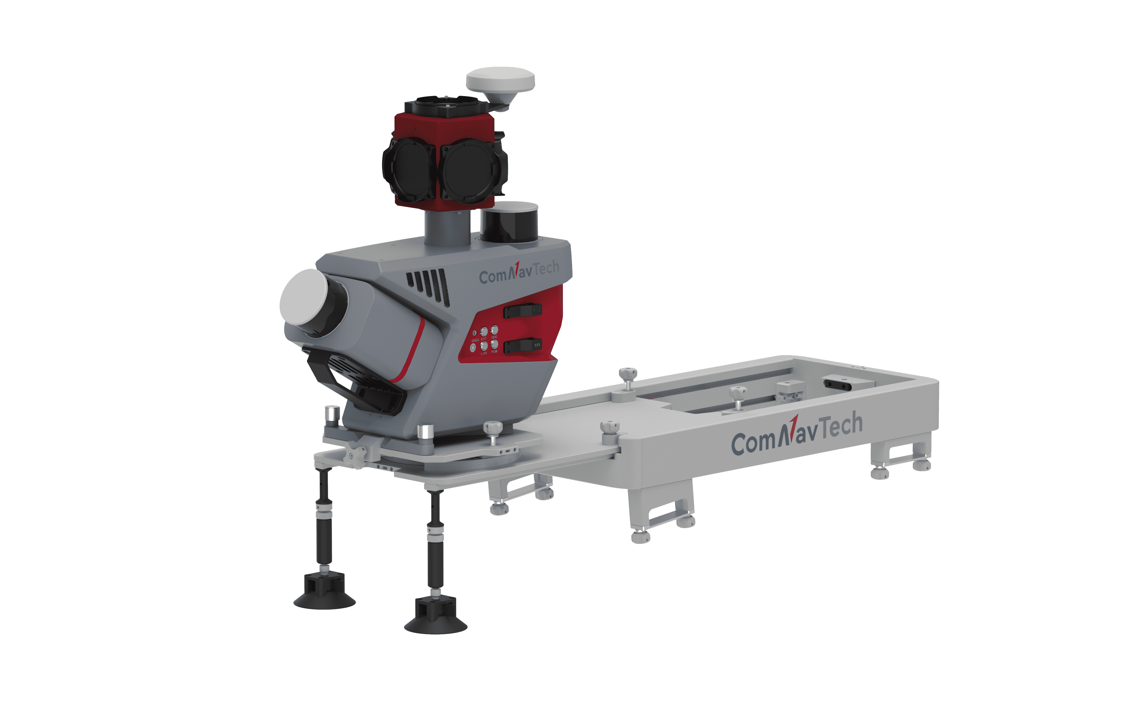
Integrated technologies
The system integrates GNSS, IMU, DMI, and LiDAR SLAM technologies, enabling it to effortlessly handle a wide range of complex scenarios. It can also achieve precise 3D reconstruction of real-world environments, even in areas where GNSS signals are unavailable.
02
Highly Integrated Flexible Installation
Integrated equipment with a quick-release design allows for rapid installation and removal. Seven predefined mounting angles (0°, ±15°, ±30°, ±45°) can be flexibly selected to meet the needs of different projects.
03
Customizable optional sensors
Compatible with optional pavement camera, front camera, DMI, and other external sensors. The pavement camera focuses on the road surface for a detailed pavement analysis. The front camera captures traffic signs at high resolution. The DMI provides assistance when satellite signals are blocked or unavailable, improving system stability.
Product Parameter
Physical
Performance
LiDAR Sensor
Camera
Physical
Dimensions508.5×263×531.5 mm
Weight14 kg
Roof Rock Dimensions730×350×95 mm
Roof Rock Weight17.5 kg
Operating Time≥6 h
PortLAN, ODO
Storage1 TB×2
Battery Capacity6000 mAh×6
Operating Temperature-10℃~ 50℃
Waterproof and DustproofIP65
Power Consumption (Typical)75 W
Power Consumption (Max)125 W
Power Supply Input Voltage24 V-DC
Interface ConnectionWi-Fi / Ethernet
Performance
Signal TrackingGPS, BDS, GLONASS, Galileo, QZSS, SBAS
IMU Data Frequency100 Hz
Position Accuracy (RMS 1ơ)Horizontal: 0.01 m
Roll / Pitch Accuracy (RMS 1ơ): 0.01°

Vertical: 0.02 m
Heading Accuracy (RMS 1ơ): 0.04°
Relative Accuracy≤2cm
Absolute Accuracy≤5 cm
Point Cloud Data FormatLAS, LAZ, LiData
Data CollectionLidar Master
LiDAR Sensor
LaserXT32M2X
Range Accuracy±1
FOV (Vertical)40.3° (-20.8° to +19.5°)
FOV (Horizontal)360°
Scan Rate1,280,000 pts/s (Dual Return)
Detection Range0.5 to 300 m
Camera
Ladybug5+
Pixels30 MP (5 MP×6 Sensors)
Maximum Frame Rate10 FPS
Image Resolution8192×4096
Sensor TypeCMOS
Trigger ModeTime / Distance Trigger
Power ConsumptionMaximum 13 W
Ladybug6 (Optional)
Pixels72 MP (12 MP×6 Sensors)
Maximum Frame Rate5 FPS
Image Resolution12288×6144
Sensor TypeCMOS
Trigger ModeTime / Distance Trigger
Power ConsumptionMaximum 13 W
Pavement / Front (Optional)
Pixels24 MP (12 MP×2 Sensors)
Maximum Frame Rate5 FPS (4096×2160)/3 FPS (4096×3000)
Image Resolution4096×3000
Sensor TypeCMOS
Trigger ModeTime / Distance Trigger
Power Consumption3.0W @ 12 VDC
Download
  • ML300 Mobile Laser Scanning System.pdf(3.1MB)
    2025-11-19
Get Information

Product Name

Name *

Phone *

E-mail *

Company

Country *

    Subscribe to Our Newsletter

    • No
    • Yes

    Inquiry Content *

    Captcha*