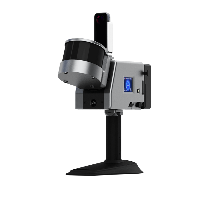
Precision Meets Efficiency: The LS300 Laser Scanner Delivers Rapid and High-Quality Data in Rigorous Test
In an impressive display of technological prowess, ComNav Technology Ltd. has completed a challenging scanning demonstration with the LS300 Laser Scanner. This test highlighted not just the speed of the LS300, but also the exceptional quality of data it can collect, setting a new benchmark in precision scanning solutions.

The LS300, equipped with state-of-the-art SLAM (Simultaneous Localization and Mapping) technology, was put to the test in a complex environment within ComNav's multi-story office building, including indoor spaces, the rooftop, and the surrounding outdoor areas with the parking lot. The test was designed to assess the scanner's adaptability, data integrity, and processing efficiency in a real-world scenario.
Detailed Testing Process:
1 Comprehensive Scanning Operation:
Over the course of 30 minutes, the LS300 scanned five levels of the building, seamlessly transitioning from indoor to outdoor environments. This included navigating narrow passages and doorways, areas traditionally challenging for scanning technology.

The comprehensive scanning operation of the LS300 is further complemented by its real-time point cloud display technology. As the device scans through various environments, from the constricted confines of staircases to the expansive outdoor areas, operators can instantly visualize the collected data on the device's interface. This immediate feedback is invaluable for ensuring coverage and data quality, allowing for on-the-fly adjustments during the scanning process. It reflects ComNav's dedication to providing user-friendly solutions that enhance productivity and decision-making in the field. The ability to see the world unfold as a detailed digital model in real time not only increases scanning efficiency but also transforms the operator's experience, making the LS300 a technological marvel in live environmental capture.

The LS300's scanning endeavor was defined by a non-circular path, where the start and end points did not coincide, presenting a rigorous test of its SLAM algorithm's precision. Despite this challenge and the reliance on a single staircase to connect multiple floors, the scanner achieved flawless stitching of the point cloud data. This level of accuracy in data integration is a testament to the advanced SLAM technology that powers the LS300. Where other devices might falter, producing layered or distorted data under similar conditions, the LS300 stands out, ensuring a seamless and accurate representation of the scanned environment. Such capabilities not only highlight the robustness of ComNav's SLAM solution but also promise users reliability in even the most demanding of scanning situations.


2 Rapid Data Processing:
Following the scan, the data was processed in a mere 20 minutes, resulting in high-fidelity LAS files ready for analysis. This rapid turnaround is indicative of the LS300's powerful onboard processing capabilities.

The LS300's prowess is further manifested in its remarkable processing speed. Unlike other SLAM-based scanning systems that require external high-power computing resources, the LS300 stands apart with its integrated onboard CPU processor. This advanced internal computing capability allows for immediate in-device data processing post-scan, eliminating the need for data export and additional processing steps. As a result, clients can promptly access and review the LAS point cloud data, dramatically streamlining their workflow. This immediate data availability, combined with the elimination of dependency on external computing setups, underscores ComNav's commitment to delivering not just performance but also unmatched efficiency and convenience to our clients.
3 Data Quality and Stability:
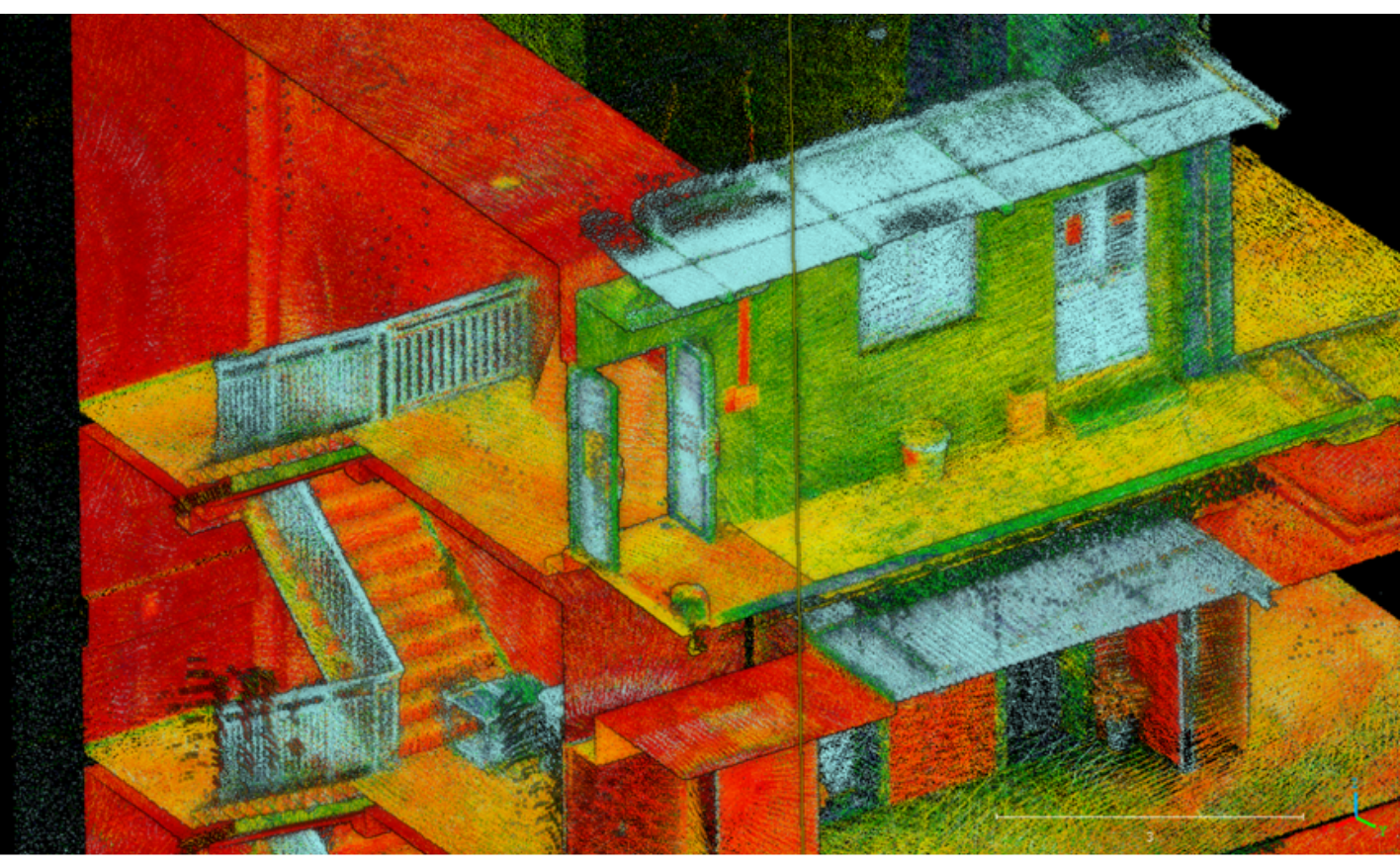
Despite the complexities of the scanning environment, the LS300 produced data of exceptional quality. There was no evidence of layering or deformation, and the integrity of the data was preserved throughout the narrow and broad spaces alike.


In the most intricate of spaces, the LS300's performance was nothing short of remarkable. The stairwells—a notoriously difficult area for scanners due to their narrow space and complex geometry—were captured with astonishing clarity. Each step, landing, and handrail emerged in the point cloud with sharp definition, showcasing the LS300's superior detail resolution capability. The scanner's precision engineering allowed it to delineate every contour and corner, proving that even in the most challenging environments, the LS300 delivers data of the highest fidelity.

4 point cloud thickness:
In the application test of the LS300 Laser Scanner, its measurements of point cloud thickness demonstrated remarkable accuracy and consistency. The scanner's ability to capture highly precise data with minimal thickness variation is particularly critical in professional surveying and mapping scenarios.


| Area | Thickness in Area 1 (mm) | Thickness in Area 2 (mm) |
|---|---|---|
| 1 | 0.013 | 0.017 |
| 2 | 0.016 | 0.015 |
| 3 | 0.0162 | 0.017 |
| 4 | 0.02 | 0.019 |
| 5 | 0.018 | 0.016 |
| 6 | 0.022 | 0.016 |
| 7 | 0.018 | 0.016 |
| 8 | 0.021 | 0.013 |
| 9 | 0.028 | 0.019 |
| 10 | 0.018 | 0.011 |
| Average | 0.01902 | 0.0159 |
| Max | 0.028 | 0.019 |
| Min | 0.013 | 0.011 |
In Specifically, the measurement results revealed that in Area 1 and Area 2, the point cloud thickness varied between 0.013 to 0.06628 millimeters and 0.011 to 0.019 millimeters, respectively, with average thicknesses of 0.01902 millimeters and 0.0159 millimeters. This minute level of variation underscores the LS300's capability to accurately capture data in complex environments while maintaining high consistency and stability in its measurements.
5 RTK-Level Accuracy:
The LS300 Laser Scanner sets a new benchmark in model stability and precision, rivaling that of RTK positioning. In a comparative analysis, the LS300's performance was meticulously evaluated against RTK measurement control points, a gold standard in geospatial accuracy. Remarkably, the scanner demonstrated a coordinate deviation within the impressive range of just 1 to 2 centimeters, effectively matching RTK-level precision.


This level of accuracy is particularly significant in applications requiring high fidelity spatial data, such as detailed site surveys and complex construction projects. The LS300's ability to achieve this with SLAM technology not only highlights its advanced capabilities but also its potential as a reliable alternative to traditional RTK methods in various scanning scenarios.
LS300 Technical Specifications and Performance:
1. Impressive Range and Speed: With a 120-meter range and a high-speed sampling rate of 320,000 points per second, the LS300 captures a dense point cloud, ensuring detailed and accurate data.
2. Precision Accuracy: The device achieves a point cloud accuracy of up to 1 centimeter, showcasing the scanner's precision in capturing the spatial relationships within the scanned area.
3. Hybrid Solution Technology (HSL): The LS300's unique HSL technology was pivotal in handling the complex indoor and outdoor mapping, offering a robust and efficient solution for data collection and processing.
4. User Experience: The LS300 features a user-friendly design, facilitating real-time viewing of point cloud data through a dedicated mobile app, which was extensively used during the testing to monitor data acquisition in real-time.
The demonstration not only highlighted the LS300's precision and efficiency but also its user-friendly design, making it an accessible tool for a wide range of applications. The successful scan of the ComNav office is a testament to the LS300's reliability, even in challenging environments.
The LS300 has proven to be a highly reliable and powerful tool, demonstrating ComNav's commitment to innovation and quality. This demonstration underscores the LS300's potential to transform the surveying and mapping industry with its advanced features and superior performance.
For further information on the LS300 and to see the scanner in action, visit ComNav Technology Official Website.
https://www.comnavtech.com/Product_details/LS300.html
About ComNav Technology
ComNav Technology develops and manufactures GNSS OEM boards and receivers for high precision positioning demanded applications. Its technology already been used in a wide range of applications such as surveying, construction, machine control, agriculture, intelligent transportation, precise timing, deformation monitoring, unmanned system. With a team dedicated for the GNSS technology, ComNav Technology is trying its best to supply reliable and competitive products to worldwide customers. ComNav Technology has been listed on the Shanghai Stock Exchange (Science and Technology Board), securities :ComNav Technology (Compass Navigation), Stock code: 688592.
About SinoGNSS®
SinoGNSS® is the official trademark of ComNav Technology Ltd., registered in People's Republic of China, EU, USA and Canada. All other trademarks are the property of their respective owners.
About ComNavTech®
ComNavTech® is the official trademark of ComNav Technology Ltd., registered in People's Republic of China, EU, USA and Canada. All other trademarks are the property of their respective owners.
