
Product Launch: MS-SAR Series Slope Monitoring Radar High-precision, All-weather, Intelligent Geohazard Monitoring Solution
Shanghai, China, August 7, 2025 - We are excited to announce the launch of our MS-SAR(synthetic aperture radar)Series Slope Monitoring Radar. In industries such as mining, water conservancy, and transportation, slope stability is critical to personnel safety and project efficiency. Traditional monitoring methods often suffer from insufficient accuracy, delayed response, and complex deployment. ComNav Technology Ltd. (ComNav)’s newly launched MS-SAR Series Slope Monitoring Radar addresses these challenges with four core advantages:Ultra-long range, Ultra-high precision, Intelligent early warning, and Flexible deployment—delivering a more efficient and reliable solution for geohazard monitoring.
1. MS-SAR1000: Lightweight and Portable Design, A Reliable Aid for Emergency Response
Portable for one person, deployable in 5 minutes—geohazard emergency monitoring has never been this efficient!
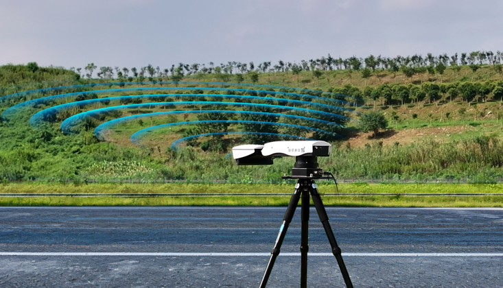
The MS-SAR1000 features a lightweight, portable design, weighing under 5 kg for easy single-person transport and rapid deployment within 5 minutes. Its arc-shaped SAR technology supports 360° or targeted area scanning, with a vertical coverage angle of up to 45°, eliminating the need for complex infrastructure. Ideal for remote mountainous areas and disaster rescue sites.
All-weather operation with intelligent early warning
With an IP65 rating, the device operates stably in extreme temperatures (-40°C to +65°C) and withstands winds up to Level 12, unaffected by rain, snow, fog, or darkness. When monitoring data exceeds preset thresholds, the system triggers multi-level alerts (audible/visual alarms, SMS notifications) and transmits real-time data via 4G/5G or satellite communication, ensuring timely slope status updates for managers.
Multi-scenario applications for road safety

ComNav has successfully implemented slope monitoring projects across China, covering rock, soil, and mixed slopes. In a recent highway slope monitoring project, the team identified 26 hazardous rock zones, integrating radar and video surveillance for automated, visual management of slope deformation—significantly improving disaster warning efficiency.
Multi-source fusion for integrated sky-ground monitoring
ComNav is currently working on a highway project in a mountainous region with extensive loess coverage and gully erosion. Rainwater erosion has caused loess sinkholes and roadbed subsidence, while heavy traffic and persistent rainfall exacerbate cumulative damage. Traditional manual inspections struggle to detect millimeter-level slope deformations.
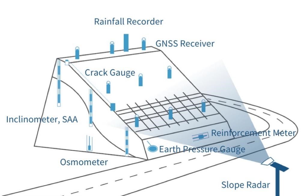
With over a decade of expertise in road engineering safety monitoring, ComNav offers a multi-source, automated slope monitoring solution for landslides, collapses, subsidence, and mudflows. This enables 24/7, high-precision real-time monitoring, enhancing the "sky-ground" integrated slope monitoring system and supporting sustainable road maintenance.
2. MS-SAR5000: Millimeter-level Accuracy + Real-time Updates - The Industry Benchmark for High Slope Monitoring
0.1mm accuracy with data refreshed every minute, leaving no room for potential risks!
In the field of slope stability monitoring, the ComNav MS-SAR5000 slope monitoring radar has become an industry benchmark for high slope monitoring with its millimeter-level accuracy and real-time data update capability. This device complements the lightweight MS-SAR1000, together forming a complete solution from emergency monitoring to long-term surveillance, providing comprehensive protection for slope safety in mining, hydropower, and transportation sectors.
Professional-grade Monitoring Performance, Complementing MS-SAR1000
The MS-SAR5000 employs SAR technology with monitoring accuracy reaching 0.1mm level, capable of precisely capturing subtle slope deformations. Compared to the sub-millimeter accuracy of MS-SAR1000, it is more suitable for critical areas requiring extremely high monitoring precision, such as large open-pit mine slopes and hydropower dam reservoir areas.
Ultra-long monitoring range of 5km, far exceeding the 800m range of MS-SAR1000, making it ideal for large-scale geological hazard monitoring. Supports 360° panoramic scanning: blind spot-free monitoring combined with differential interferometry technology to generate high-precision deformation data in real time. Data updates every minute ensure the timeliness of monitoring results, providing the latest basis for decision-making.
All-weather Stable Operation, Adaptable to Extreme Environments
Similar to MS-SAR1000, the MS-SAR5000 features IP65 protection rating and can operate in extreme temperatures from -30°C to +60°C. However, its 40W low-power design and multiple power supply modes (mains power/diesel generator/solar) make it more suitable for long-term fixed monitoring scenarios, while MS-SAR1000 focuses more on portable emergency use.
Flexible Deployment and Intelligent Management
The MS-SAR5000 adopts a 12kg modular design, slightly heavier than the 5kg MS-SAR1000, but supports both fixed long-term monitoring and emergency deployment modes. Unlike the rapid deployment feature of MS-SAR1000, the MS-SAR5000 excels in building system-level monitoring networks.
✔ Fixed monitoring: Suitable for mining areas, hydropower projects and other scenarios requiring long-term surveillance, accumulating high-precision data to build slope stability assessment models.
✔ Emergency deployment: Rapid response to sudden geological hazards, working in coordination with MS-SAR1000 to form a "fixed + mobile" monitoring network.
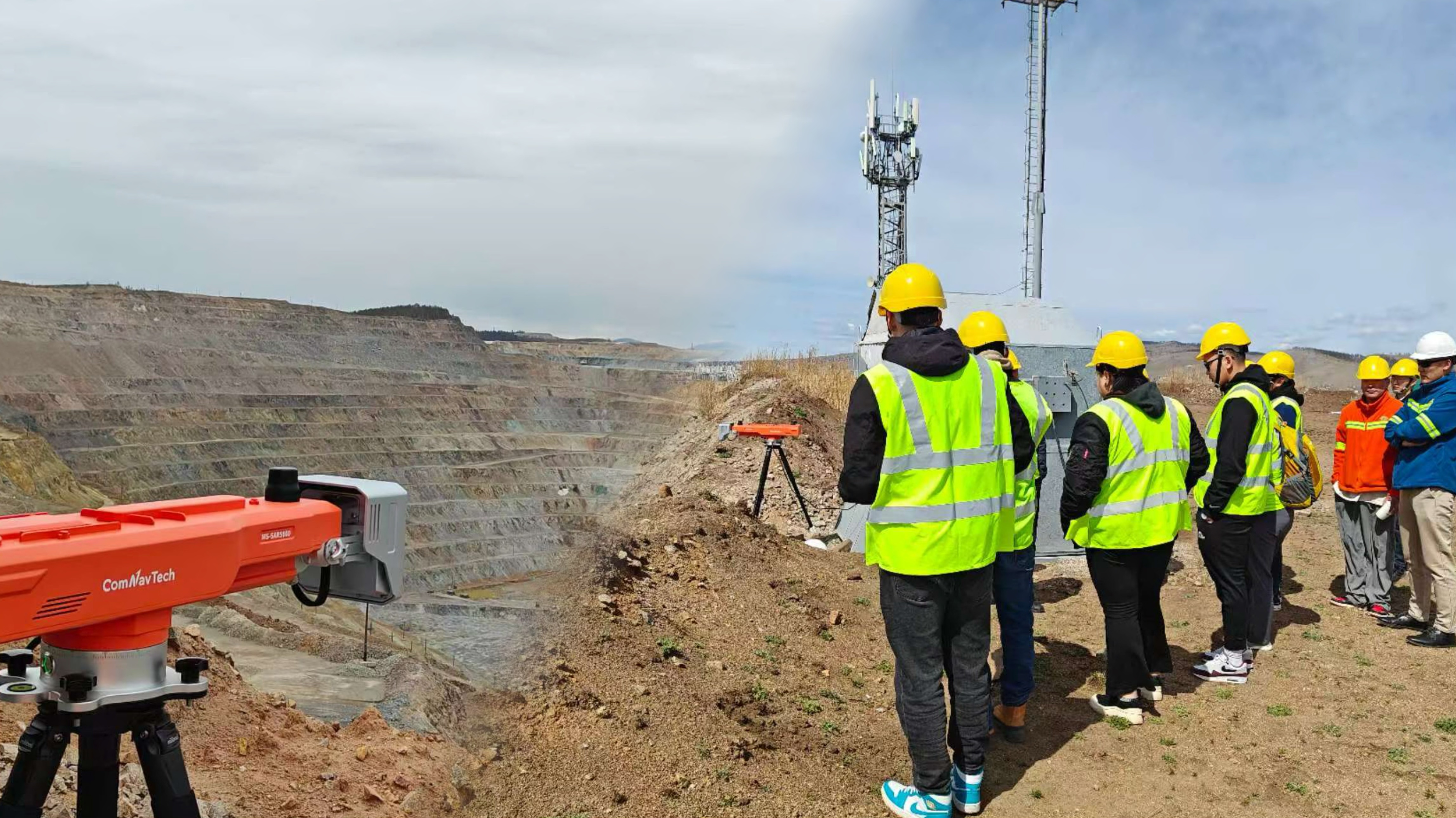
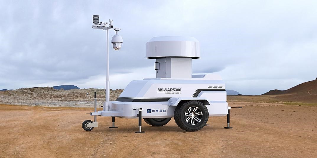
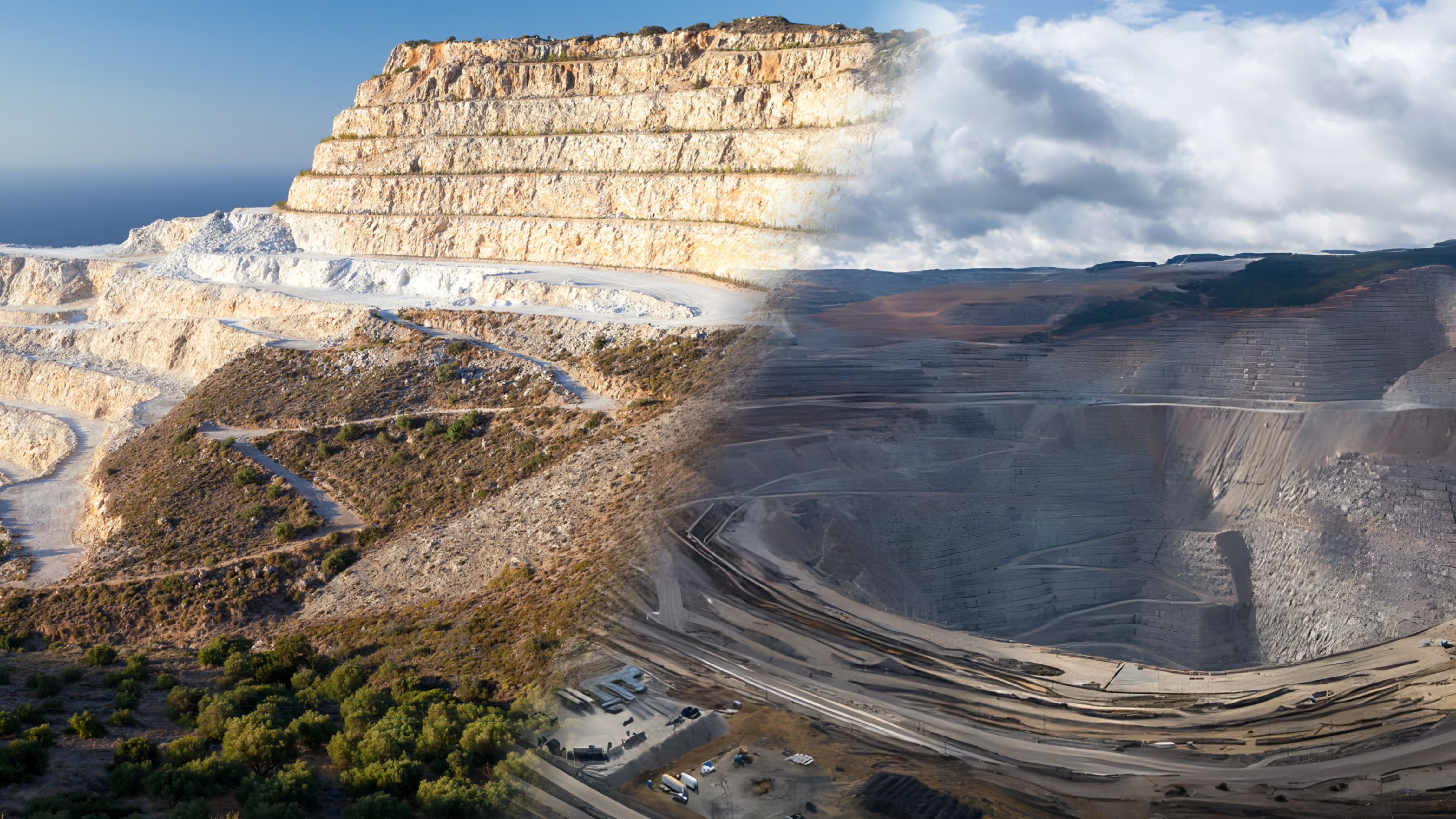
3. MS-SAR5300: Large-scale Mobile Monitoring, Intelligent Guardian for Mine Safety
5km ultra-long-range monitoring + trailer-mounted rapid deployment for complete coverage of open-pit mine slope monitoring!
In the field of slope monitoring, ComNav’s MS-SAR series has formed a complete technological matrix. The newly launched MS-SAR5300, as an integrated trailer-mounted radar monitoring station, complements the portable MS-SAR1000 and high-precision fixed MS-SAR5000 with differentiated features. It is specifically designed for large open-pit mines, hydropower projects, and other scenarios requiring dynamic monitoring position adjustments.
It can be quickly towed to monitoring points for dynamic scanning. Its radar-3D fusion technology can capture millimeter-level deformations caused by landslides, collapses, and debris flows in real time, while providing instant warnings through the intelligent cloud platform to ensure safe and efficient mine operations.
Core Advantages: Mobile Monitoring & System Integration
All-terrain mobility: Equipped with an off-road chassis + independent leveling system for rapid deployment on complex mine roads, overcoming the limitation of difficult relocation after fixed installation of MS-SAR5000. Integrated power, communication, and air conditioning systems enable "stop-and-use" operation, emphasizing sustained operational capability compared to the portability of MS-SAR1000.
Multi-hazard integrated monitoring: Supports linkage with GNSS, rain gauges, soil moisture sensors and so on, building a more comprehensive multi-parameter warning system than MS-SAR1000/5000. The radar-3D fusion technology enables stereoscopic deformation field imaging, compensating for the perspective limitations of single-radar monitoring.
Ultra-large-scale coverage: Maintains the same 5km monitoring radius as MS-SAR5000 but achieves patrol monitoring across dozens of square kilometers through trailer mobility.
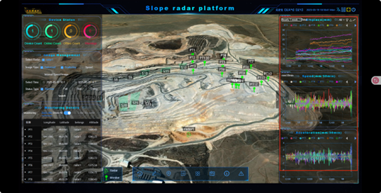
4. Intelligent Management Platform: SmartMonitor
All MS-SAR series are equipped with ComNav’s self-developed SmartMonitor cloud platform, enabling:
✔ Multi-device data fusion analysis
✔ 3D deformation field dynamic simulation
✔ Tiered warning (SMS/audio-light/email)
✔ Real-time mobile viewing
Multi-user online collaboration, real-time data sharing, and multi-sensor (GNSS, rain gauge, etc.) fusion analysis. Through SMS, email, audio-light alerts, and other warning methods, users can grasp slope conditions anytime, anywhere, significantly improving emergency response efficiency.
Technology Leads, Safety Follows
ComNav has established a three-tier technical system through the combined application of the MS-SAR series products, ranging from centimeter-level survey (MS-SAR1000), millimeter-level monitoring (MS-SAR5000) to dynamic precision measurement (MS-SAR5300), providing precise support for slope safety management at different stages.
The MS-SAR Series revolutionizes slope monitoring with precision, flexibility, and intelligence—your best defense against geohazards.
Ready to upgrade your monitoring system? Experience next-generation slope safety with ComNav’s industry-leading technology!
Click here: Slope Stability Monitoring Solution
About ComNav Technology
ComNav Technology develops and manufactures GNSS OEM boards and receivers for high precision positioning demanded applications. Its technology already been used in a wide range of applications such as surveying, construction, machine control, agriculture, intelligent transportation, precise timing, deformation monitoring, unmanned system. With a team dedicated for the GNSS technology, ComNav Technology is trying its best to supply reliable and competitive products to worldwide customers. ComNav Technology has been listed on the Shanghai Stock Exchange (Science and Technology Board), securities :ComNav Technology (Compass Navigation), Stock code: 688592.
About SinoGNSS®
SinoGNSS® is the official trademark of ComNav Technology Ltd., registered in People's Republic of China, EU, USA and Canada. All other trademarks are the property of their respective owners.
About ComNavTech®
ComNavTech® is the official trademark of ComNav Technology Ltd., registered in People's Republic of China, EU, USA and Canada. All other trademarks are the property of their respective owners.