
Innovation Unleashed: ComNav’s Product Launch Sets New Benchmarks
Shanghai, China, March 19, 2025 - ComNav Technology Ltd. (ComNav) hosted a forward-looking product launch event, officially unveiling its latest innovations. These products are designed to raise industry benchmarks, ignite boundless creativity, and propel performance to new heights, showcasing ComNav’s leadership in technological innovation while delivering more efficient solutions to users worldwide.
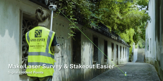
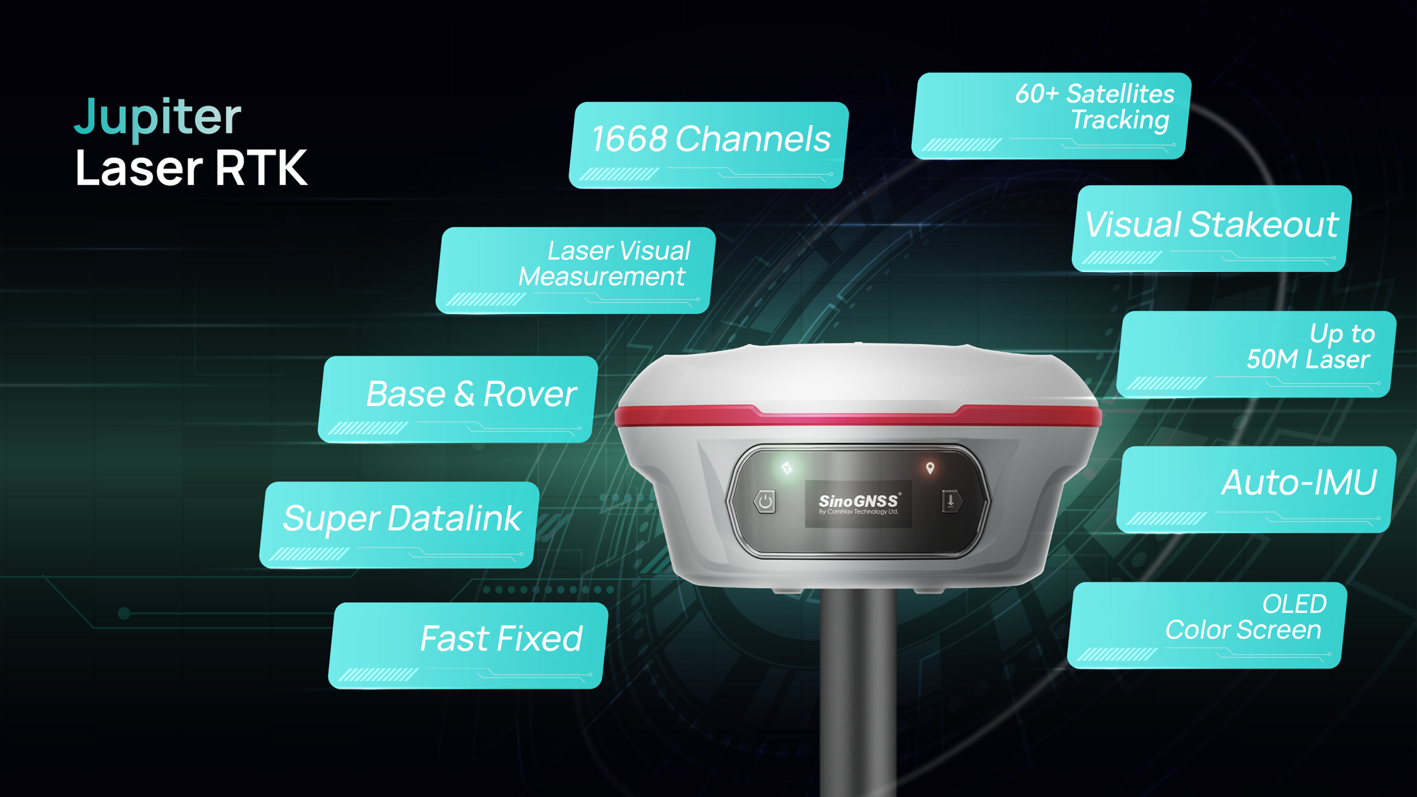
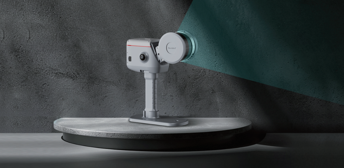
➤ Jupiter Laser RTK: Reshaping the Future of Surveying and Stakeout
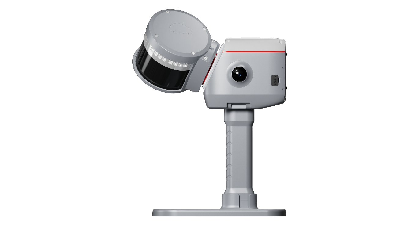
In recent years, ComNav has consistently delved into market needs and committed to relentless R&D, integrating laser technology with RTK to create an innovation in the market — the Universe Series GNSS Receiver. Now, ComNav proudly introduces the latest masterpiece in this series — Jupiter Laser RTK. Extending its laser range to 50 meters with centimeter-level accuracy, this product replaces traditional poles with laser technology. Jupiter excels in both routine and complex scenarios. Whether in alleys with tree-blocked signals, hard-to-reach lake pavilions, or hazardous roads, it ensures safe and efficient surveying and stakeout, delivering a seamless experience. Equipped with a global night vision camera paired with laser technology, Jupiter maintains high efficiency for survey and stakeout tasks even in low-light or nighttime conditions, with its laser clearly visible in the dark.
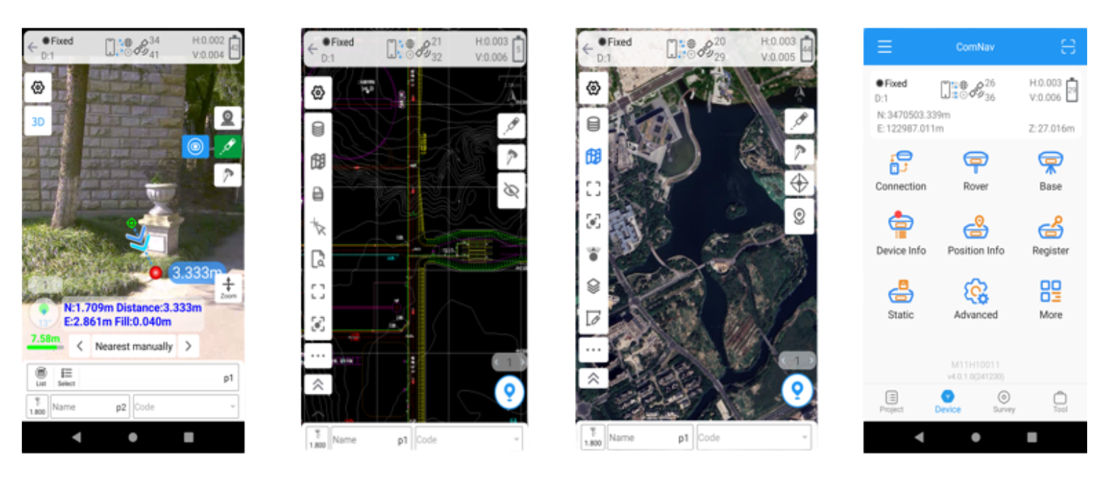
The Jupiter Laser RTK enhances operational ease with its visualized survey and stakeout capabilities. Through a handheld data collector featuring an intuitive interface, users can effortlessly view point positions. With Survey Master software’s 3D visual interface, operators can simply follow directional arrows and real-time distances to accurately mark stakeout points on the ground. Even less experienced operators can complete survey and stakeout tasks in one go, without repeatedly adjusting the pole. Its innovative dual-camera system guides stakeout paths with the front camera at long distances and switches to the bottom camera for detailed views at close range, ensuring one-shot precision and boosting efficiency by 30%. As you are near the stakeout point, a flashing laser replaces traditional walkie-talkies, offering an intuitive design that elevates user experience. In bright light or at long distances, visualization compensates for the laser’s invisibility to the naked eye, ensuring survey and stakeout accuracy.

Additionally, Jupiter Laser RTK integrates cutting-edge technologies: the K8 board enables full-constellation and multi-frequency tracking with 1668 channels, capable of tracking over 60 satellites; its Super Datalink offers a 15-kilometer working range, compatible with mainstream protocols for true full-protocol support; and its Auto IMU provides up to 120° tilt compensation without manual initialization, supporting automatic calibration. With exceptional quality, long battery life, and waterproof, drop-resistant design, Jupiter performs reliably in both standard and demanding environments, meeting diverse user needs.
➤ Survey Master Update: Your New Partner in Smart Surveying
Survey Master software has undergone a significant upgrade, making it more powerful and user-friendly, with outstanding compatibility, seamless file sharing, a robust CAD engine, and high-performance surveying capabilities. This update brings:
➥ Brand New UI Interface: Optimized based on user habits, Survey Master features a new visualization interface, restructured CAD layout, and a flexible toolbar consolidating common functions across scenarios for enhanced usability.
➥ Upgraded CAD Engine: As ComNav’s self-developed core component, CADX enables instant loading of large drawings for smooth operation, while SinoGeoX seamlessly integrates CAD with maps, enhancing the drawing experience.
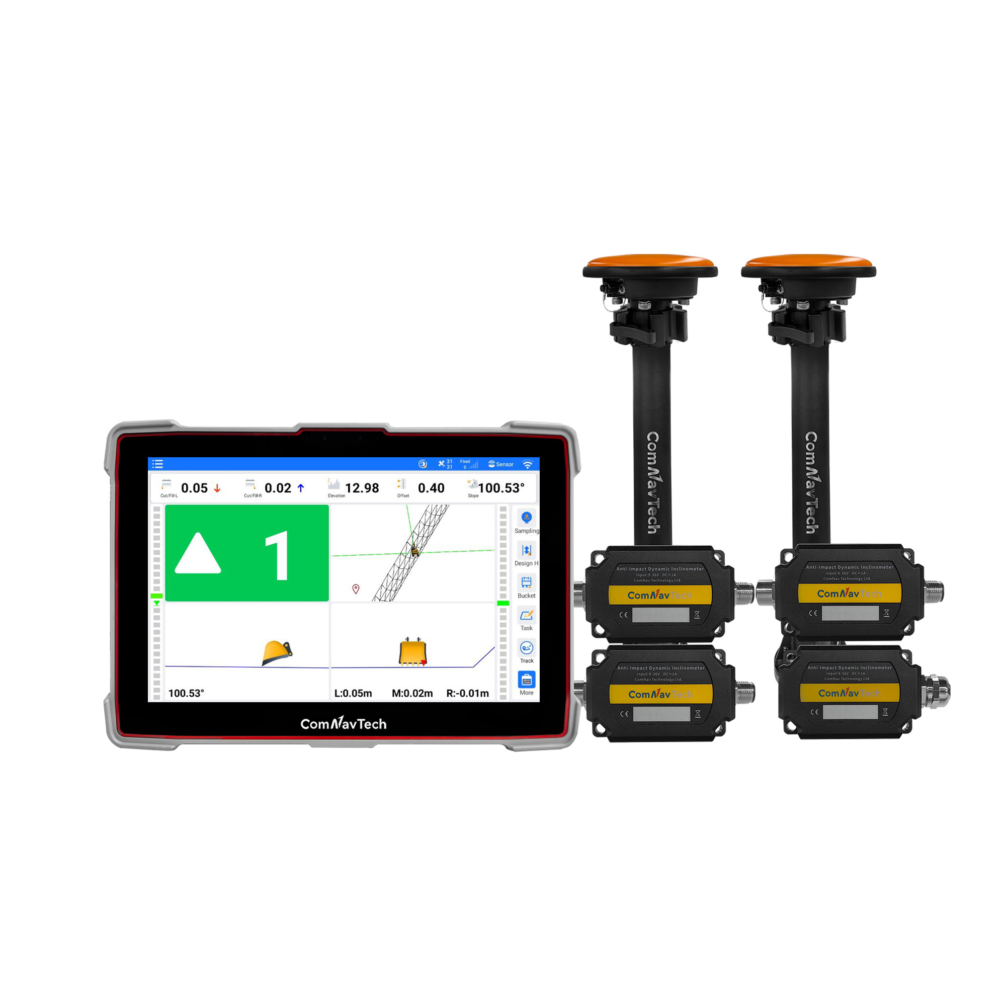
➥ Standing Survey: In IMU mode, activate Standing Survey to automatically measure points after the receiver remains stationary for 2 seconds—no manual clicks required.
➥ Enhanced File Sharing: Files can be downloaded via QR code scanning on handheld collectors or other devices, with one-click transfers between collectors, smartphones, and PCs, enabling cross-platform collaboration and rapid sharing.
➥ RTK PPP Fusion: When RTK signals drop, it seamlessly switches to PPP solutions, maintaining operational continuity with PPP accuracy up to 20 centimeters.
➥ Echo Sounder and WMS Compatibility: It supports echo sounders for precise depth data and WMS services for synchronized, customizable map data.
Survey Master redefines the surveying experience with intelligence and efficiency, becoming an indispensable partner for users.
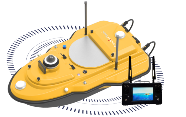
➤ SV600 Unmanned Surface Vessel: A Smart Pioneer in Water Operations
The SV600 is a state-of-the-art unmanned surface vessel (USV) engineered for hydrographic surveying, blending cutting-edge technology with exceptional performance to deliver an unmatched remote-control experience. It seamlessly integrates adaptive water-flow straight-line and hovering technology, boosting efficiency while ensuring every task is handled with ease. Featuring a unique dual-moon pool design, the SV600 can simultaneously deploy advanced equipment—from Acoustic Doppler Current Profilers (ADCP), Single-Beam Echo Sounders (SBES), Side-Scan Sonar, and pipeline detectors to miniaturized Multi-Beam Echo Sounders—meeting diverse surveying needs with unrivaled flexibility. Its rapid installation feature allows effortless task transitions, enabling smooth switches among measurement modes. The SV600 makes hydrographic surveying smarter and more efficient.
➤ LS600: Next-Level 3D Scanning Made Simple and Precise
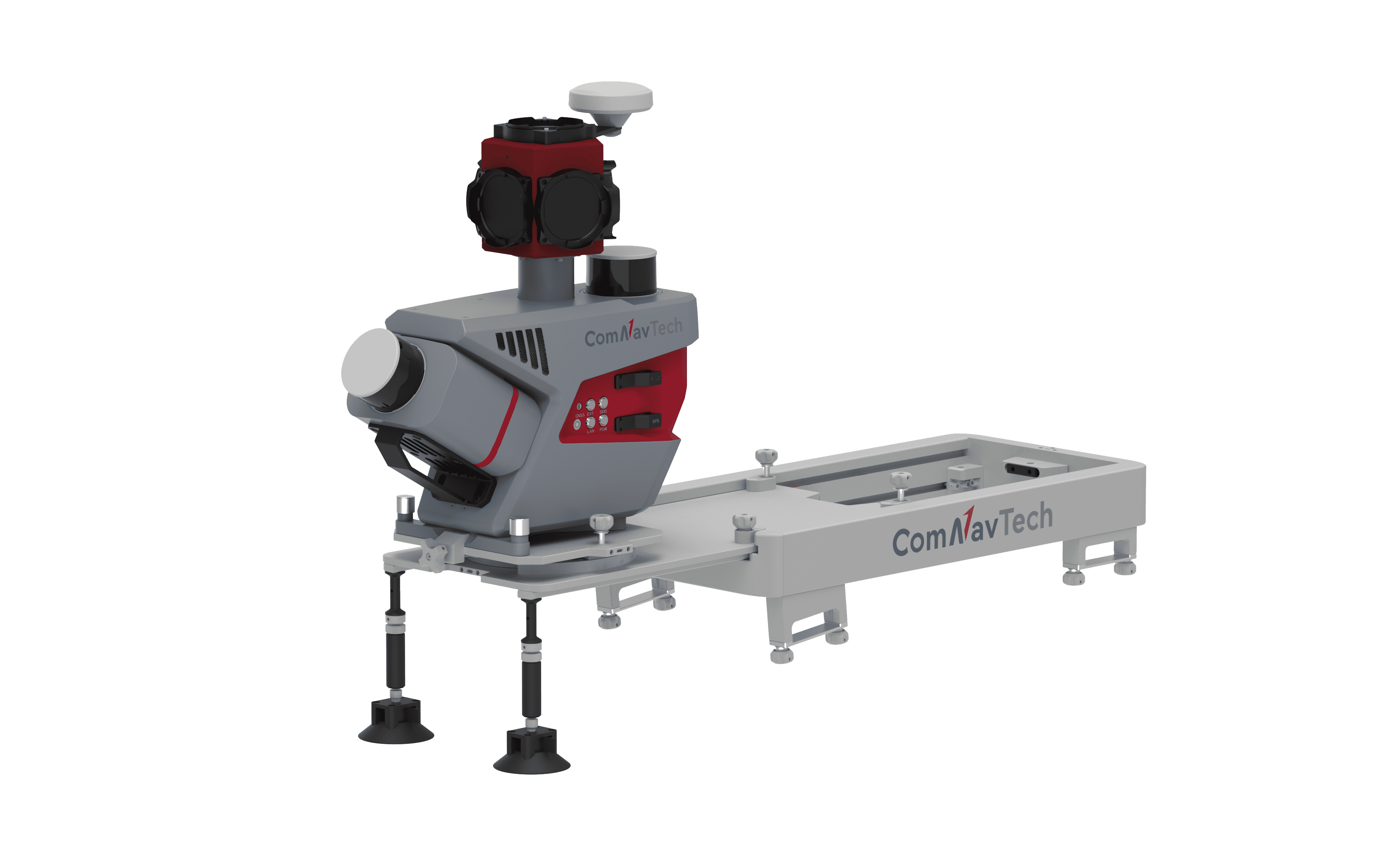
Additionally, ComNav introduced the LS600 this time — a next-generation handheld 3D laser scanner that seamlessly blends advanced SLAM technology, a built-in RTK module, and dual 16MP wide-angle cameras. With multi-sensor fusion, such as LiDAR, IMU, and cameras, it provides excellent performance both indoors and outdoors. It offers 16- or 32-line LiDAR options, with a scanning range up to 300 meters and a speed of 640,000 points per second for fast data capture. The advanced GNSS module ensures centimeter-level accuracy with full-frequency GNSS support,while the built-in surveying antenna improves signal reliability. The dual-lens camera, paired with V-SLAM, create detailed, color point clouds for clear and realistic visuals. Meanwhile, the LS600 supports backpack and pole modes, making it adaptable for various tasks like land surveying, engineering, urban renewal, mining, agriculture, forestry, and emergency response. Its automated post-processing stitching, denoising, and rendering and flexible coordinate systems make precision and efficiency easy to achieve, helping you stand out in the surveying field!
At this launch event, we unveiled four groundbreaking products, and we firmly believe they will not only meet but exceed your expectations, delivering unparalleled value and efficiency to your operations. For personalized support or inquiries, please reach out to our sales team at: sales@comnavtech.com.
About ComNav Technology
ComNav Technology develops and manufactures GNSS OEM boards and receivers for high precision positioning demanded applications. Its technology already been used in a wide range of applications such as surveying, construction, machine control, agriculture, intelligent transportation, precise timing, deformation monitoring, unmanned system. With a team dedicated for the GNSS technology, ComNav Technology is trying its best to supply reliable and competitive products to worldwide customers. ComNav Technology has been listed on the Shanghai Stock Exchange (Science and Technology Board), securities :ComNav Technology (Compass Navigation), Stock code: 688592.
About SinoGNSS®
SinoGNSS® is the official trademark of ComNav Technology Ltd., registered in People's Republic of China, EU, USA and Canada. All other trademarks are the property of their respective owners.
About ComNavTech®
ComNavTech® is the official trademark of ComNav Technology Ltd., registered in People's Republic of China, EU, USA and Canada. All other trademarks are the property of their respective owners.