A Quick Method for Calculating Precise Coordinates (1 cm Accuracy) Anywhere in the World
With advancing GNSS technology and growing user demands, CORS systems now enable centimeter-level real-time positioning and millimeter-level post-processing accuracy. ComNav Technology Ltd applies these systems across surveying, mapping, intelligent transportation, autonomous driving, and precision agriculture, offering high-precision GNSS solutions.
High-precision base stations in CORS systems enhance accuracy by transmitting GNSS data to control servers. Base station coordinates, crucial for precision, are typically determined via static observation or joint measurement, but these methods can be labor-intensive or impractical in areas without stations.
PPP online services, like Canada’s CSRS-PPP, simplify this process. Users upload GPS observation files (RINEX format) to obtain high-precision coordinates via email, making it an efficient alternative for base station setup.
1 Solution process of PPP online positioning service system
The main process of calculating high precision coordinates based on CSRS-PPP online software is shown in Fig. (1).
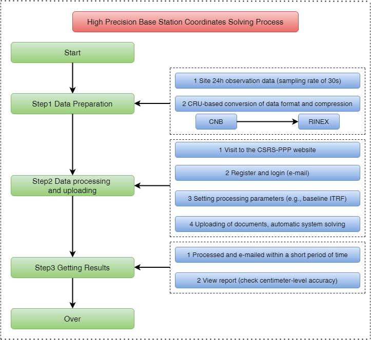
Fig. (1) Flowchart of CSRS-PPP for Calculating High-Precision Coordinates
The solution process is described in detail.
1.1 Data Preparation
1.1.1 Downloading GPS observations from the site, here using ComNav Technology Ltd's product M300 Pro as an example.
(a) Log in to the M300 Pro's web interface (mainly used for device configuration and data caching and downloading, etc.).
(b) Cache the station's 24-hour observation data(GPS only is suggested) and configure parameter values, such as data format, observation period, sampling rate (30 seconds), etc. The parameter setting interface is shown in Figure (4) below.
Among them, the supportable data formats include CNB, RINEX2.10, RINEX3.02, RINEX3.04,RTCM, and NMEA.
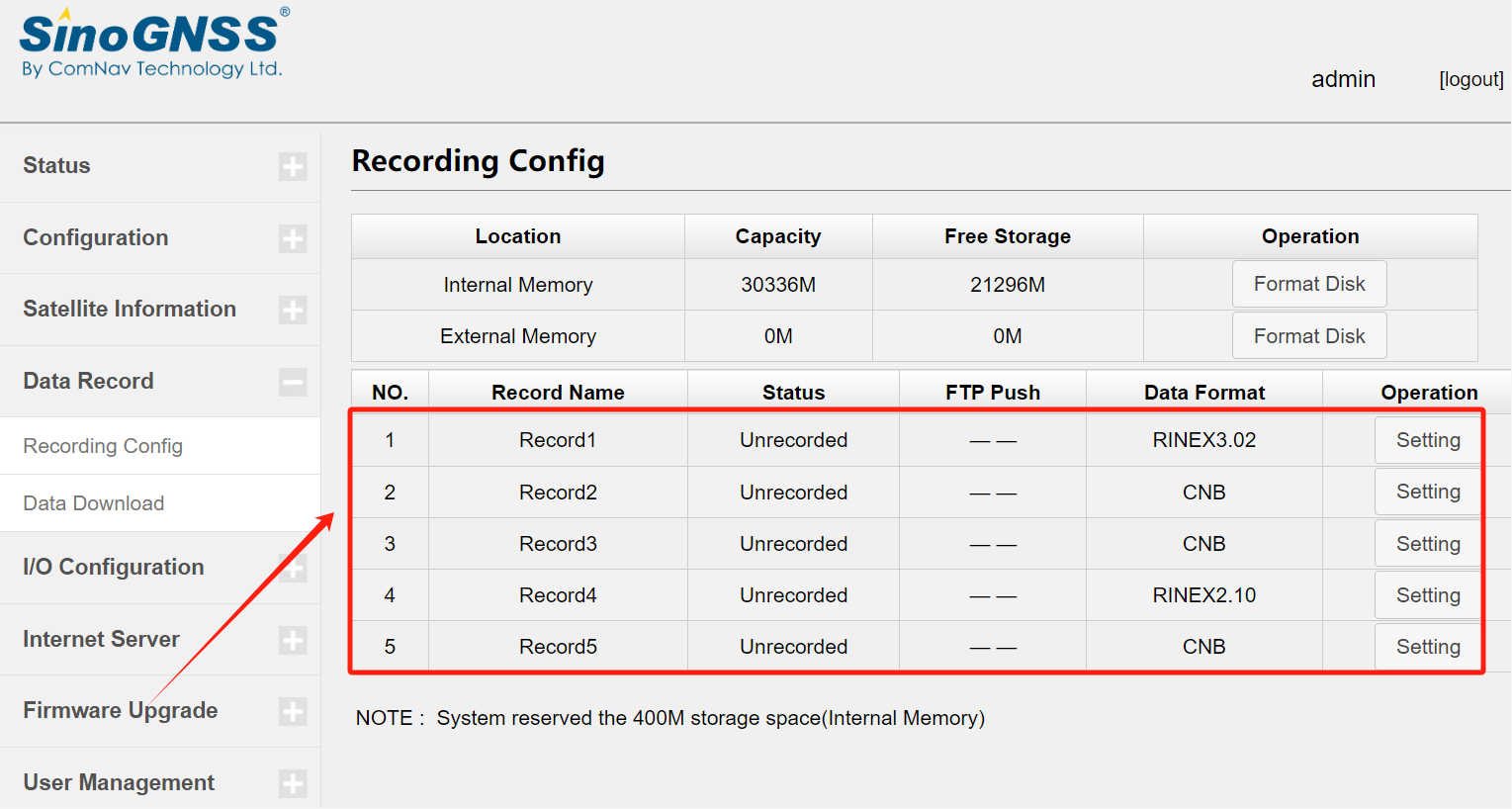
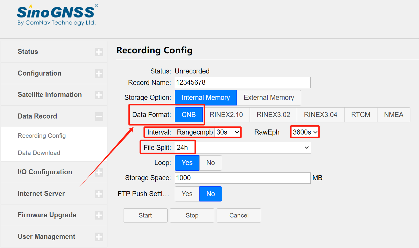
Figure (4) Site Data Cache Parameters Setting
(c) The cache is finished and you can download the file directly.

Figure (5) CNB Format Site Observation Data File
1.1.2 If the station observation data are in RINEX format, this step is skipped. Otherwise, the data need to be converted to RINEX format before they can be uploaded to CSRS-PPP for solving. To convert CNB format to RINEX format, for example, use Compass Receiver Utility (i.e., CRU) software to convert non-RINEX format data to RINEX format files and compress them. The CRU conversion process is as follows:
(a) Open CRU software and open the folder where the file is located in the "Directory" column.
(b) Open the "RINEX" module in the "Function" column, select the file to be converted, and set "Antenna", "Setup" and "Convert" as shown in Figure (6).

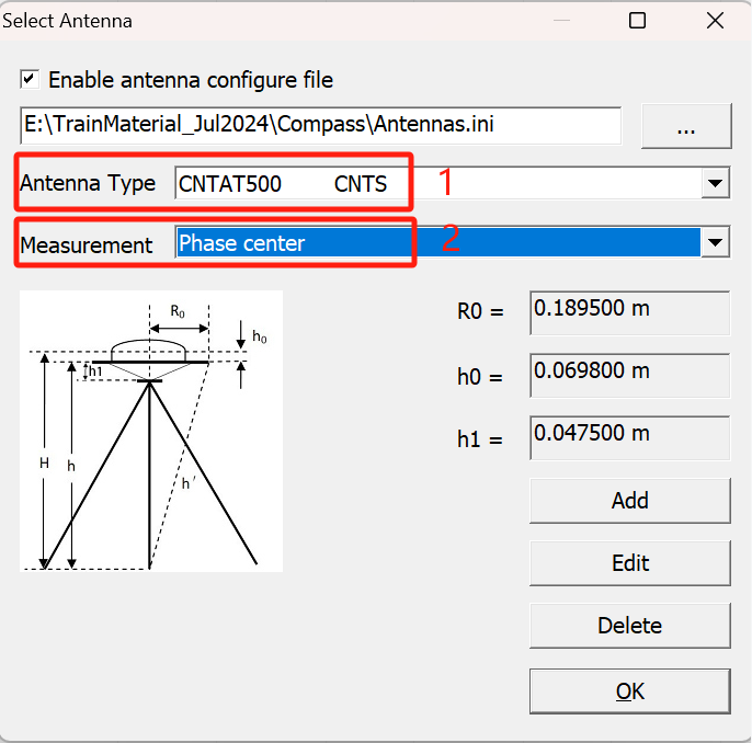
(c) In "Antenna", set the parameters "Antenna Type" and "Measurement", and the specific settings are shown in Figure (7).
(d) In the "Setup" set the parameters "Export Format", "Sample Rate" and "Export Observation", the specific settings are shown in Figure (8).
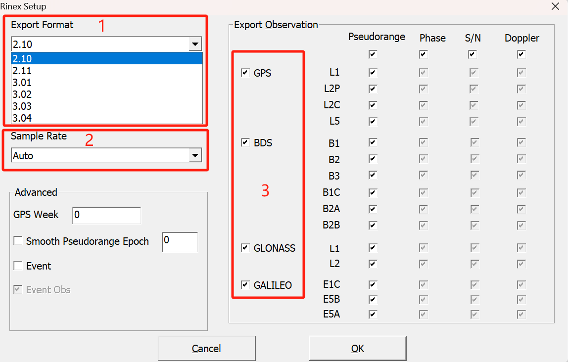
Figure (8) "RINEX" Conversion Parameter Settings
(e) Click "Convert" to convert, after the conversion is completed, the observation files in RINEX format and the navigation files of each system (BDS, GPS, GLONASS, GALILEO, QZSS) are automatically saved to the current folder.

1.2 Data processing and uploading
1.2.1 Enter the CSRS-PPP website.
1.2.2 log in (email), you need to register an account for the first time.
https://webapp.csrs-scrs.nrcan-rncan.gc.ca/geod/tools-outils/ppp.php?locale=en
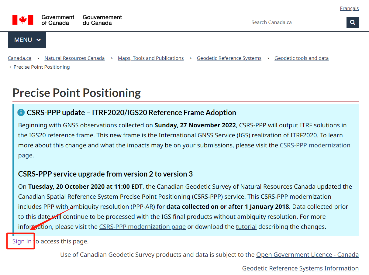
Figure (10) CSRS-PPP System Login Interface
1.2.3 After successful login, set the processing parameters as shown in Figure (11), the specific process is as follows:
a. Enter the email account password.
b. Select the type of data to process (static as an example).
c. Select the coordinate datum used for the data (ITRF as an example).
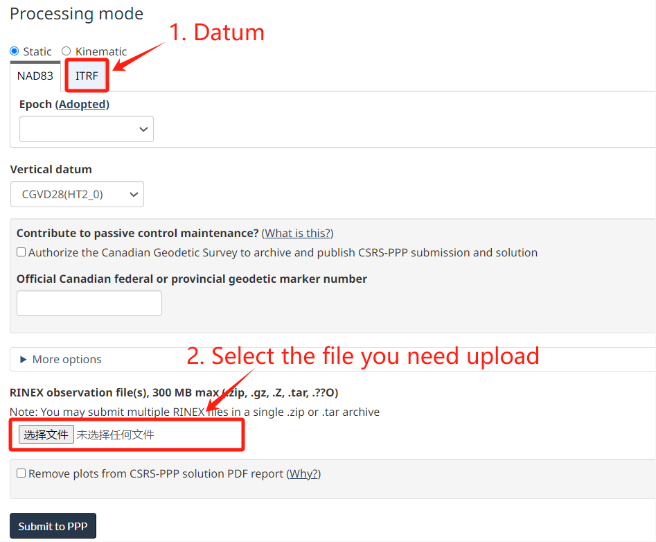
Figure (11) CSRS-PPP System Upload Station Observation File Parameters Setting
1.2.4 Select the zip file of observations for the site to be processed and upload it to the PPP website.
1.3 Getting results
1.3.1 A few minutes after submitting the data, the system will send the site high-precision solution results and a detailed report to the user's mailbox, as shown in Figure (12) and Figure (13).

Figure (12) CSRS-PPP Solved Site Results Zip file
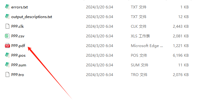
Figure (13) PPP Coordinate Solution results
1.3.2 Check the accuracy of the reported data results (e.g., Sigma, the discrete value of positioning accuracy corresponding to the coordinates in the ITRF frame), and if the requirements cannot be met, record another set of data and recalculate.
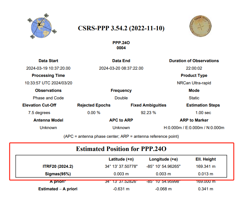
Figure (14) Indicators for Assessing the Accuracy of Site Resolution
2 Cautions
2.1 Observation period: Although the CSRS-PPP system does not have the requirement of the shortest GPS observation period, too short an observation period will easily affect the accuracy of the positioning results, and most of the observation data are collected for 24h.
2.2 Data quality: Avoid observation in areas with serious signal interference to ensure good quality of GPS observation data.
2.3 File size: GPS observation files are less than 100MB, and the system can process observation files for 6 days at most.
About ComNav Technology
ComNav Technology develops and manufactures GNSS OEM boards and receivers for high precision positioning demanded applications. Its technology already been used in a wide range of applications such as surveying, construction, machine control, agriculture, intelligent transportation, precise timing, deformation monitoring, unmanned system. With a team dedicated for the GNSS technology, ComNav Technology is trying its best to supply reliable and competitive products to worldwide customers. ComNav Technology has been listed on the Shanghai Stock Exchange (Science and Technology Board), securities :ComNav Technology (Compass Navigation), Stock code: 688592.
About SinoGNSS®
SinoGNSS® is the official trademark of ComNav Technology Ltd., registered in People's Republic of China, EU, USA and Canada. All other trademarks are the property of their respective owners.
About ComNavTech®
ComNavTech® is the official trademark of ComNav Technology Ltd., registered in People's Republic of China, EU, USA and Canada. All other trademarks are the property of their respective owners.
