Messages to get velocity information from GNSS
Velocity is a crucial parameter in collecting navigation information, significantly influencing navigation accuracy and performance. ComNav's products excel at capturing and tracking satellite signals, providing valuable information about velocity during movement. In this blog, we will introduce some logs related to speed as below:
GPVTG BESTVEL BESTXYZ GPRMC GPNAV GPYBM KSXT AGRIC DRONE
1 GPVTG
This message is commonly used to output velocity data, which includes the direction angle and motion speed, allowing us to obtain the motion trajectory of an object.
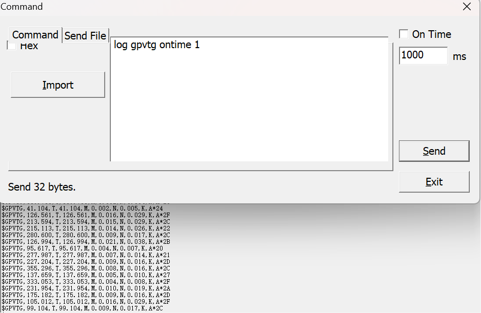
Fig.1 GPVTG message
Input command: log gpvtg ontime 1
Here is the standard output format of GPVTG:
$GPVTG,148.030,T,158.030,M,0.304,N,0.563,K,D*27Where 0.304 is speed in knots, 0.563 is speed in km/h.
2 BESTVEL
This message contains the best available velocity information computed by the board. In addition, it reports a velocity status indicator, which is useful in indicating whether the corresponding data is valid. The velocity measurements sometimes have a latency associated with them. The time of validity is the time tag in the log minus the latency value.
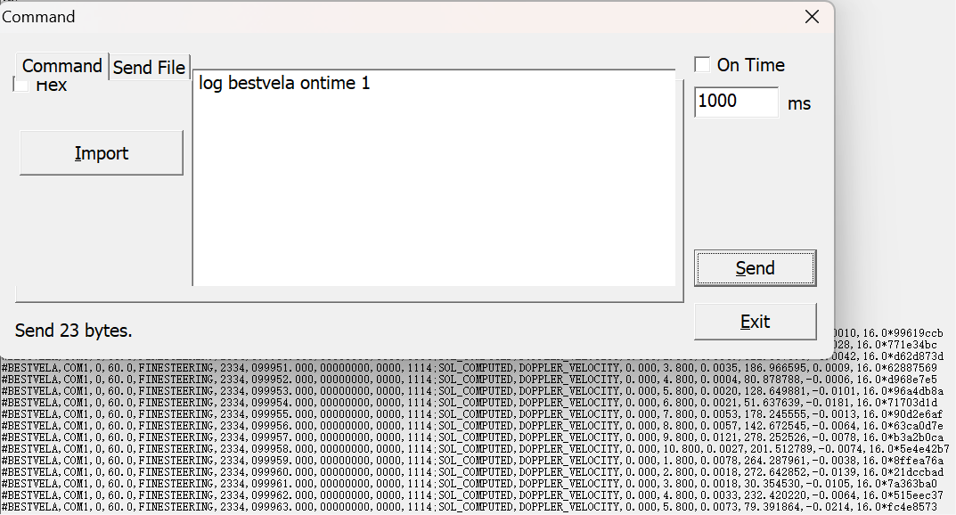
Fig.2 BESTVEL message
Input command: log bestvela ontime 1
Here is a standard output format of BESTVEL message:
#BESTVELA,COM1,0,60.0,FINESTEERING,2222,378338.000,00000000,0000,1114;SOL_COMPUTED,DOPPLER_VELOCITY,0.000,1.000,0.0020,193.563897,0.0003,4.0*af2f3c2eWhere 0.0020 is horizontal velocity to ground in m/s; 0.0003 is the velocity in the vertical direction in m/s, positive values indicate the upward direction, negative value means downward direction.
3 BESTXYZ
This message includes the device's best velocity in ECEF coordinates.
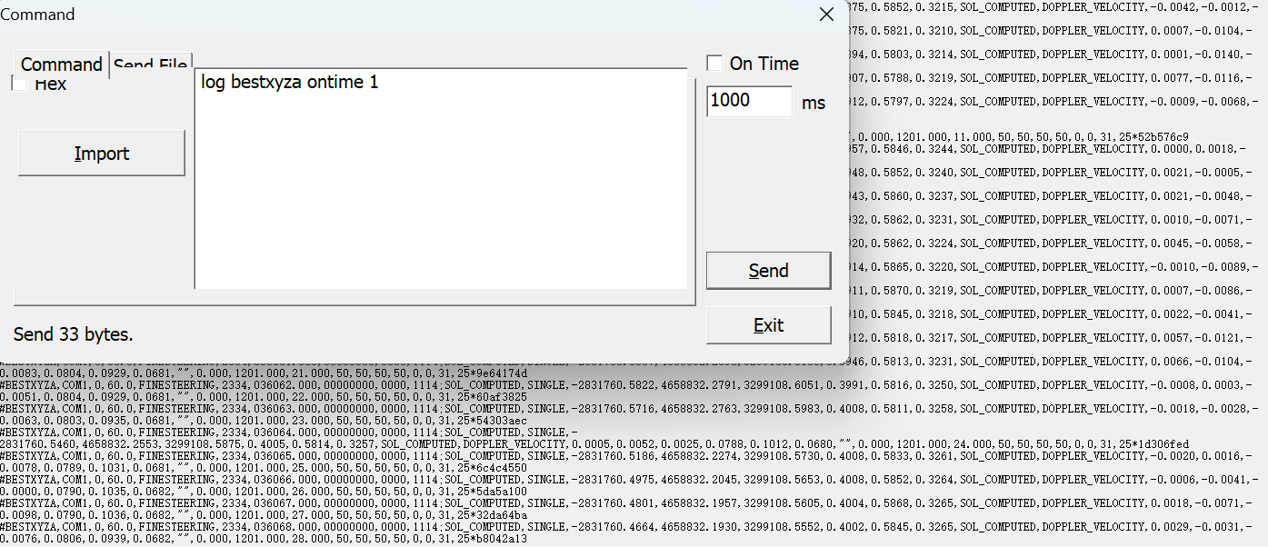
Fig.3 BSETXYZ message
Input command: log bestxyza ontime 1
The standard DRONE message format is as follows:
#BESTXYZA,COM1,0,60.0,FINESTEERING,2222,378599.000,00000000,0000,1114;SOL_COMPUTED,NARROW_INT,-2831765.8413,4658833.3032,3299109.2852,0.0079,0.0094,0.0078,SOL_COMPUTED,DOPPLER_VELOCITY,0.0014,0.0001,-0.0018,0.0033,0.0041,0.0034,"0008",0.000,1.000,10.000,46,40,46,46,0,0,0,203*f94f1bd1
Where 0.0014, 0.0001 and 0.0018 represent the velocity in the x, y and z directions.
4 GPRMC
This message contains time, position, speed and real heading angle, and is a standard NMEA message. Compared with GPVTG, this message provides position info.
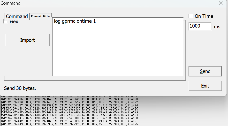
Fig.4 GPRMC message
Input command: log gprmc ontime 1
Here is a standard output format of GPRMC message:
$GPRMC,074539.00,A,3120.9969570,N,12117.5424237,E,000.004,133.5,120822,10.0,W,D*1CWhere 000.004 is speed in knots.
5 GPNAV
This message is a non-standard message, which includes position, velocity, position and tracking information, and also heading, pitch and roll (reserved) angles output while dual antennas are used.
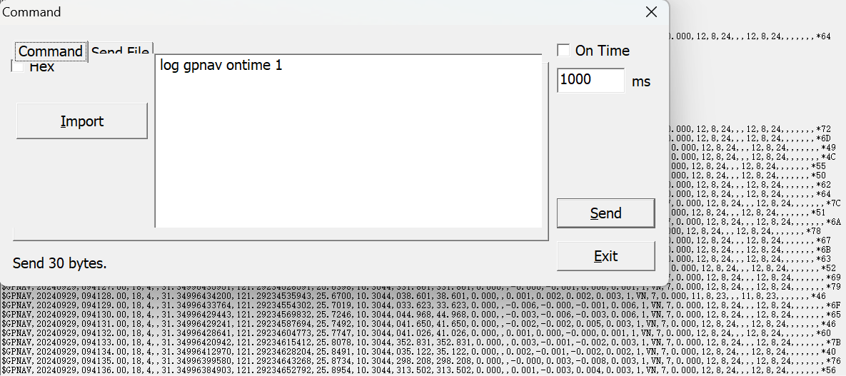
Fig.5 GPNAV message
Input command: log gpnav ontime 1
Here is a standard output format of GPNAV message:
$GPNAV,20151003,123707.00,17,3,,31.17432494563,121.38795557054,41.7907,10.7811,176.628,0.000,0.000,,0.000,-0.002,-0.010,0.002,1,NN,7,0.000,8,5,9,,,8,5,9,,,,,,,*6FWhere 0.002 is ground speed in m/s.
6 GPYBM
This message is a non-standard message, which includes position, velocity, PJK information. This message can output velocity information in different directions, including northward, eastward, vertical speed, and ground speed.
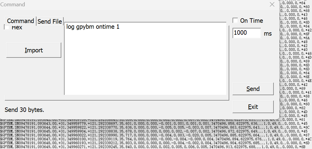
Fig.6 GPYBM message
Input command: log gpybm ontime 1
Here is a standard output format of GPYBM message:
$GPYBM,SN00520429,070326.00,+31.170243388,+121.398934274,15.286,346.840,1.290,0.000,-0.002,0.003,0.002,3449917.897,538032.213,-451.861,1088.741,4,4,12,1,,,,*4BThe values 0.000, -0.002, 0.003, and 0.002 represent the northward velocity, eastward velocity, vertical speed, and ground speed, respectively, with all units in m/s.
7 KSXT
This message outputs the speed of the GNSS device, as well as the eastward, northward, and upward velocities in the geographic coordinate system, with units in km/h.
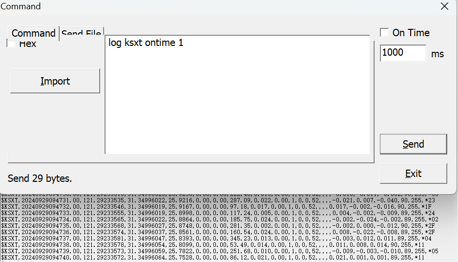
Fig.7 KSXT message
Input command: log ksxt ontime 1
The standard KSXT message format is as follows:
$KSXT,20210906104914.00,121.29239578,31.34996850,33.3672,276.66,43.34,83.17,0.102,0.00,1,3,39,42,,,,0.101,0.012,0.143,95,94,*21Where 0.102 represents the velocity, and 0.101,0.012,0.143 represent eastward, northward, and upward velocity separately.
8 AGRIC
This message outputs the speed of the GNSS device, as well as the eastward, northward, and upward velocities. In addition, the message also gives the standard deviation of the speed in different directions.
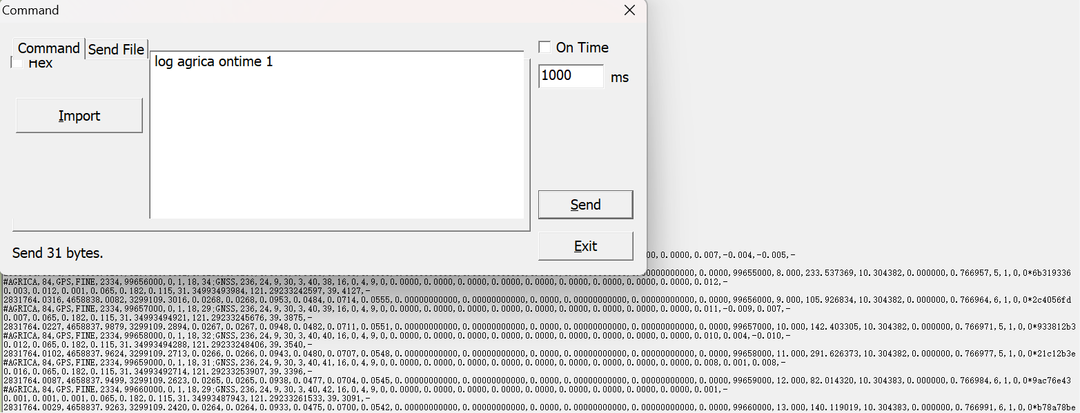
Fig.8 AGRIC message
Input command: log agrica ontime 1
Here is the standard format of AGRIC:
#AGRICA,35,GPS,FINE,2223,283006000,0,1,18,27;GNSS,236,22,8,17,6,36,28,4,4,14,21,0,-7782.5864,-2000.3002,8.4380,0.0046,0.0056,0.0041,243.0610,-0.2899,0.0000,0.013,-0.010,0.008,-0.012,0.013,0.015,0.012,31.34996227620,121.29240322121,36.6529,-2831767.7449,4658831.1477,3299110.4542,0.0194,0.0194,0.0280,0.0043,0.0053,0.0039,31.42015535053,121.31342487993,23.1344,31.34994264898,121.29236881723,42.6828,283006000,1.000,139.352203,10.304612,2.753604,0.717130,0,0,0,0*acab1bc9 Here 0.013 represents the speed of the GNSS device, -0.010 is the velocity of north, 0.008 is the velocity of east, -0.012 is the velocity of vertical direction.
9 DRONE
This message displays real-time status information for the dual-antenna system, including the speed of the master antenna, and related accuracy data.
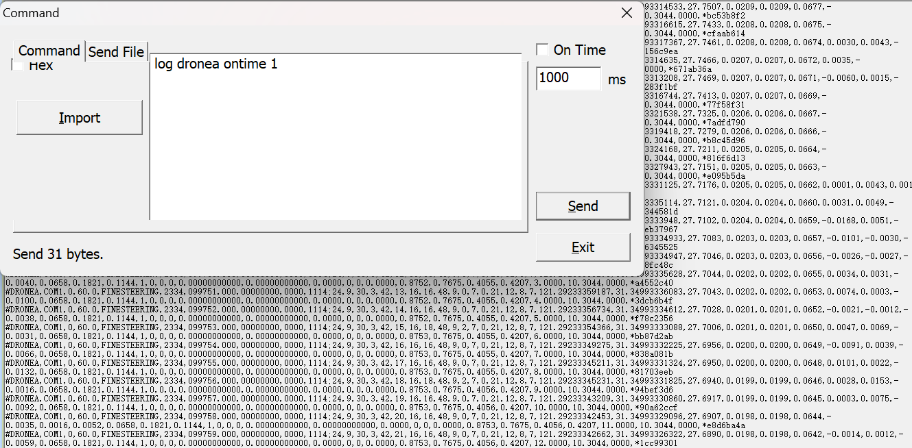
Fig.9 DRONE message
Input command: log dronea ontime 1
The standard DRONE message format is as follows:
#DRONE,COM1,0,60.0,FINESTEERING,2263,267570.000,00000000,0000,1114,23,5,24,2,19,12,1,45,45,21,12,7,5,21,12,7,5,121.29169275851,31.35089750559,27.8769,0.3036,0.3035,1.4278,0.0006,-0.0006,0.0146,0.0165,0.0024,0.0036,1,1,45,45,121.29162252337,31.35088292530,28.8125,1,4,248.7460,1.0419,0.8830,0.4550,0.5530,0.0000,10.3014,4096,*4ff8b7c6Where -0.0006, 0.0006 and 0.0146 represent the northern, eastern and ground speed separately.
NOTE: Detailed message definitions can be found in the OEM manual.
About ComNav Technology
ComNav Technology develops and manufactures GNSS OEM boards and receivers for high precision positioning demanded applications. Its technology already been used in a wide range of applications such as surveying, construction, machine control, agriculture, intelligent transportation, precise timing, deformation monitoring, unmanned system. With a team dedicated for the GNSS technology, ComNav Technology is trying its best to supply reliable and competitive products to worldwide customers. ComNav Technology has been listed on the Shanghai Stock Exchange (Science and Technology Board), securities :ComNav Technology (Compass Navigation), Stock code: 688592.
About SinoGNSS®
SinoGNSS® is the official trademark of ComNav Technology Ltd., registered in People's Republic of China, EU, USA and Canada. All other trademarks are the property of their respective owners.
About ComNavTech®
ComNavTech® is the official trademark of ComNav Technology Ltd., registered in People's Republic of China, EU, USA and Canada. All other trademarks are the property of their respective owners.
