Alert on Strong Geomagnetic Storming and How Ionospheric Activity Impact on GNSS Performance
The 23 March CME arrived at around 24/1411 UTC. Severe (G4) geomagnetic storming has been observed and is expected to continue through the remainder of the 24 March-UTC day and into the first half of 25 March. The alert issued by NOAA's Space Weather Prediction Center in Boulder, Colorado.

image from NASA
The CME process occurred almost directly opposite the Earth, so when viewed from the Earth, the ejection formed a circular surface, which is what we mentioned in the past as the "full halo". The solar material ejected by such explosive activities is faster than the earth and has a high coverage, which may cause relatively strong geomagnetic activity.
Geomagnetic storms will interfere with communications and navigation. The main reason is that the ionizing radiation during geomagnetic storms will interfere with the ionosphere of the earth's atmosphere, causing ionospheric scintillation and ionospheric delay, which will in turn affect radio communications and navigation and positioning systems, resulting in Positioning error or interruption. For users who rely on GNSS for navigation and positioning, especially high-precision applications, operating activities should be reasonably arranged.
In addition to geomagnetic storms that affect ionospheric activity, periodic solar activity also has a huge impact on ionospheric activity, thereby affecting satellite positioning and navigation services.
Introduction to Ionospheric Activity
The ionosphere is a region of Earth's upper atmosphere, extending from about 30 miles (48 kilometers) above the Earth's surface to several hundred miles in altitude. It is a dynamic and ever-changing layer characterized by the presence of ionized or charged particles, primarily electrons and positively charged ions. These charged particles are created through the process of ionization, which is primarily driven by solar radiation. As solar energy reaches the Earth's upper atmosphere, it causes neutral gases to become ionized, leading to the formation of the ionosphere.
The ionospheric active cycle is usually associated with cyclic changes in solar activity, and the duration of a cycle is about 11 years. The current solar activity cycle is expected to peak between 2024 and 2026. Ionospheric activities will directly affect the propagation and reception of GNSS satellite signals, which may lead to a decrease in positioning accuracy. Generally speaking, ionospheric activity is more active at lower latitudes, so the impact on high-precision users around the equator may be more significant.
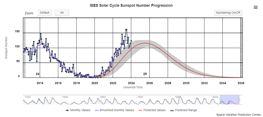
NOAA Space weather prediction center
The Effects of Ionospheric Activity on GNSS Performance
Ionospheric activity, influenced by factors such as solar radiation and geomagnetic storms, can have several effects on GNSS performance. Understanding these effects is crucial for accurate positioning and navigation. Here are the key impacts of ionospheric activity on GNSS:
The ionosphere causes delays in GNSS signals as they pass through the ionized layers. Delay is frequency-dependent, with higher-frequency signals experiencing greater delays. This delay can lead to inaccuracies in the calculation of signal travel time, affecting position estimation.
Higher-frequency GNSS signals, such as those in the L2 band, are more susceptible to ionospheric dispersion. Dispersion causes the different frequencies of the signal to travel at different speeds, leading to spreading and distortion of the signal. Frequency dispersion can result in inaccuracies in phase measurements and impact positioning accuracy.
Ionospheric scintillation refers to rapid fluctuations in signal amplitude and phase caused by irregularities in the ionosphere. Scintillation effects are more pronounced in equatorial and high-latitude regions. Scintillation can lead to signal loss, tracking errors, and increased uncertainty in GNSS measurements.
Geomagnetic storms, triggered by solar activity, can intensify ionospheric disturbances. During geomagnetic storms, increased electron density in the ionosphere can lead to stronger signal delays and scintillation. Storm-induced disturbances may result in temporary GNSS service outages and degraded accuracy.
Mitigating the Effects of Ionospheric Activity
Users are advised to consider the following recommendations when using GNSS positioning to fully utilize the latest algorithms and reduce the impact of ionospheric activity:
Ensure that the receiver firmware is updated to the latest version to optimize positioning performance during ionospheric activity using the latest algorithms.
Dual-frequency or triple-frequency receivers can utilize signals of different frequencies to calculate and correct ionospheric delays, thereby improving positioning accuracy.
In addition to the GPS system, consider using satellite signals from other GNSS systems such as GLONASS, Galileo, BeiDou, etc. Using multiple satellite systems can increase the amount of observation data, enhancing positioning reliability and accuracy.
Setting the satellite elevation angle to 10 degrees can reduce the impact of the ionosphere on satellites closest to the horizon. Setting a higher satellite elevation angle can mitigate signal propagation delays caused by the ionosphere.
In summary, by implementing measures such as updating receiver firmware, using dual-frequency or triple-frequency receivers, utilizing multiple satellite systems, and adjusting satellite elevation angles, users can better address positioning errors during ionospheric activity, thereby improving the accuracy and reliability of GNSS positioning.
About ComNav Technology
ComNav Technology develops and manufactures GNSS OEM boards and receivers for high precision positioning demanded applications. Its technology already been used in a wide range of applications such as surveying, construction, machine control, agriculture, intelligent transportation, precise timing, deformation monitoring, unmanned system. With a team dedicated for the GNSS technology, ComNav Technology is trying its best to supply reliable and competitive products to worldwide customers. ComNav Technology has been listed on the Shanghai Stock Exchange (Science and Technology Board), securities :ComNav Technology (Compass Navigation), Stock code: 688592.
About SinoGNSS®
SinoGNSS® is the official trademark of ComNav Technology Ltd., registered in People's Republic of China, EU, USA and Canada. All other trademarks are the property of their respective owners.
About ComNavTech®
ComNavTech® is the official trademark of ComNav Technology Ltd., registered in People's Republic of China, EU, USA and Canada. All other trademarks are the property of their respective owners.
